You are here: Home > Network List > UW - Pacific Northwest Regional Seismic Network Stations List
> Station UMAT Pilot Rock, OR, USA > Earthquake Result Viewer
UMAT Pilot Rock, OR, USA - Earthquake Result Viewer
| Earthquake location: |
Near Coast Of Central Chile |
| Earthquake latitude/longitude: |
-34.2/-72.3 |
| Earthquake time(UTC): |
2019/08/01 (213) 18:28:05 GMT |
| Earthquake Depth: |
10 km |
| Earthquake Magnitude: |
6.8 mww |
| Earthquake Catalog/Contributor: |
NEIC PDE/us |
|
| Network: |
UW Pacific Northwest Regional Seismic Network |
| Station: |
UMAT Pilot Rock, OR, USA |
| Lat/Lon: |
45.29 N/118.96 W |
| Elevation: |
1318 m |
|
| Distance: |
89.7 deg |
| Az: |
329.1 deg |
| Baz: |
142.937 deg |
| Ray Param: |
0.04172311 |
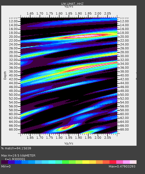
| Estimated Moho Depth: |
19.5 km |
| Estimated Crust Vp/Vs: |
1.93 |
| Assumed Crust Vp: |
6.571 km/s |
| Estimated Crust Vs: |
3.405 km/s |
| Estimated Crust Poisson's Ratio: |
0.32 |
|
| Radial Match: |
94.15839 % |
| Radial Bump: |
389 |
| Transverse Match: |
87.587135 % |
| Transverse Bump: |
385 |
| SOD ConfigId: |
19053131 |
| Insert Time: |
2019-08-15 18:38:33.312 +0000 |
| GWidth: |
2.5 |
| Max Bumps: |
400 |
| Tol: |
0.001 |
|
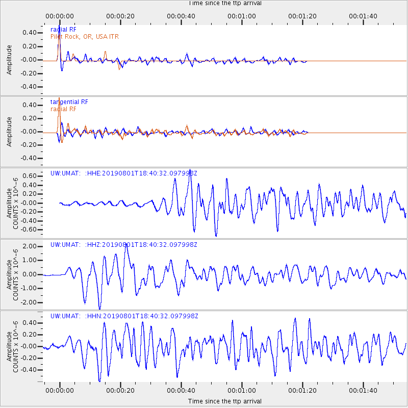
Signal To Noise
| Channel | StoN | STA | LTA |
| UW:UMAT: :HHZ:20190801T18:40:32.097998Z | 5.598207 | 2.5242505E-7 | 4.509034E-8 |
| UW:UMAT: :HHN:20190801T18:40:32.097998Z | 2.6865432 | 8.6902695E-8 | 3.2347405E-8 |
| UW:UMAT: :HHE:20190801T18:40:32.097998Z | 2.9603434 | 9.117246E-8 | 3.0797935E-8 |
| Arrivals |
| Ps | 2.8 SECOND |
| PpPs | 8.5 SECOND |
| PsPs/PpSs | 11 SECOND |


