You are here: Home > Network List > TA - USArray Transportable Network (new EarthScope stations) Stations List
> Station S09A Goldfield, NV, USA > Earthquake Result Viewer
S09A Goldfield, NV, USA - Earthquake Result Viewer
| Earthquake location: |
Kuril Islands |
| Earthquake latitude/longitude: |
49.8/156.4 |
| Earthquake time(UTC): |
2006/08/20 (232) 03:01:02 GMT |
| Earthquake Depth: |
26 km |
| Earthquake Magnitude: |
5.8 MB, 5.7 MS, 6.0 MW, 5.9 MW |
| Earthquake Catalog/Contributor: |
WHDF/NEIC |
|
| Network: |
TA USArray Transportable Network (new EarthScope stations) |
| Station: |
S09A Goldfield, NV, USA |
| Lat/Lon: |
37.72 N/117.23 W |
| Elevation: |
1768 m |
|
| Distance: |
60.2 deg |
| Az: |
65.763 deg |
| Baz: |
311.858 deg |
| Ray Param: |
0.061645266 |
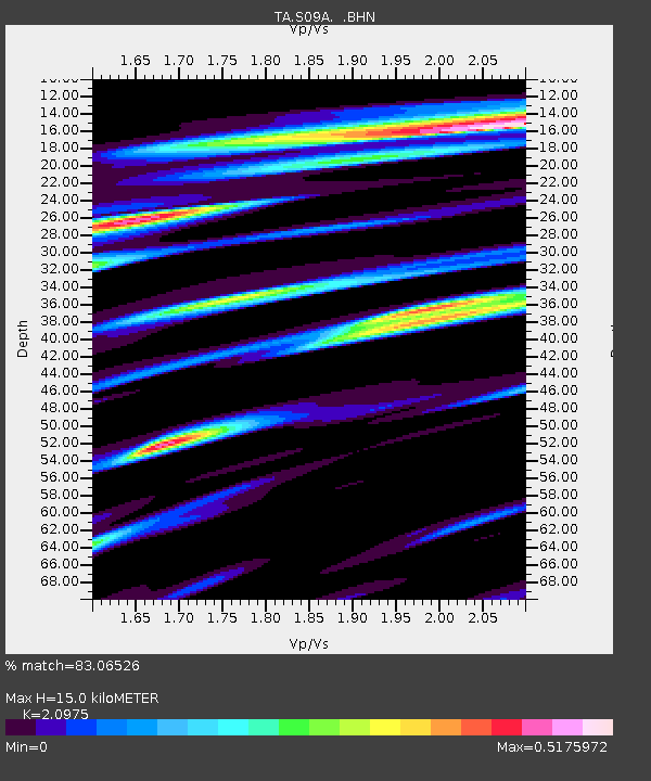
| Estimated Moho Depth: |
15.0 km |
| Estimated Crust Vp/Vs: |
2.10 |
| Assumed Crust Vp: |
6.279 km/s |
| Estimated Crust Vs: |
2.993 km/s |
| Estimated Crust Poisson's Ratio: |
0.35 |
|
| Radial Match: |
83.06526 % |
| Radial Bump: |
400 |
| Transverse Match: |
64.42172 % |
| Transverse Bump: |
400 |
| SOD ConfigId: |
2665 |
| Insert Time: |
2010-03-07 02:40:09.701 +0000 |
| GWidth: |
2.5 |
| Max Bumps: |
400 |
| Tol: |
0.001 |
|

Signal To Noise
| Channel | StoN | STA | LTA |
| TA:S09A: :BHN:20060820T03:10:37.149014Z | 2.9712682 | 1.7130006E-7 | 5.765217E-8 |
| TA:S09A: :BHE:20060820T03:10:37.149014Z | 2.2686865 | 1.7392145E-7 | 7.666174E-8 |
| TA:S09A: :BHZ:20060820T03:10:37.149014Z | 4.720602 | 4.1689532E-7 | 8.831402E-8 |
| Arrivals |
| Ps | 2.7 SECOND |
| PpPs | 7.1 SECOND |
| PsPs/PpSs | 9.9 SECOND |


