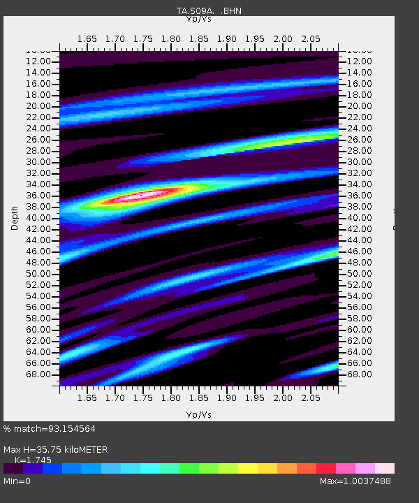
S09A Goldfield, NV, USA - Earthquake Result Viewer

Earthquake location: Rat Islands, Aleutian Islands
Earthquake latitude/longitude: 51.8/177.1
Earthquake time(UTC): 2006/06/14 (165) 04:18:42 GMT
Earthquake Depth: 14 km
Earthquake Magnitude: 5.9 MB, 6.4 MS, 6.4 MW, 6.4 MW
Earthquake Catalog/Contributor: WHDF/NEIC
Network: TA USArray Transportable Network (new EarthScope stations)
Station: S09A Goldfield, NV, USA
Lat/Lon: 37.72 N/117.23 W
Elevation: 1768 m
Distance: 47.1 deg
Az: 80.335 deg
Baz: 309.392 deg
Ray Param: 0.0701754
Estimated Moho Depth: 35.75 km
Estimated Crust Vp/Vs: 1.75
Assumed Crust Vp: 6.279 km/s
Estimated Crust Vs: 3.598 km/s
Estimated Crust Poisson's Ratio: 0.26
Radial Match: 93.154564 %
Radial Bump: 400
Transverse Match: 82.12064 %
Transverse Bump: 400
SOD ConfigId: 5745
Insert Time: 2010-03-07 02:40:22.048 +0000
GWidth: 2.5
Max Bumps: 400
Tol: 0.001

Signal To Noise

ChannelStoNSTALTA
TA:S09A: :BHN:20060614T04:26:43.325002Z2.42304781.6984302E-77.0094785E-8
TA:S09A: :BHE:20060614T04:26:43.325002Z2.00566241.4471925E-77.215534E-8
TA:S09A: :BHZ:20060614T04:26:43.325002Z3.58561854.6288767E-71.2909564E-7
Arrivals
Ps4.5 SECOND
PpPs15 SECOND
PsPs/PpSs19 SECOND