You are here: Home > Network List > TS - TERRAscope (Southern California Seismic Network) Stations List
> Station ISA Isabella, California, USA > Earthquake Result Viewer
ISA Isabella, California, USA - Earthquake Result Viewer
| Earthquake location: |
Southeast Of Honshu, Japan |
| Earthquake latitude/longitude: |
32.5/141.7 |
| Earthquake time(UTC): |
1992/08/11 (224) 15:14:56 GMT |
| Earthquake Depth: |
28 km |
| Earthquake Magnitude: |
5.8 MB, 6.2 MS |
| Earthquake Catalog/Contributor: |
WHDF/NEIC |
|
| Network: |
TS TERRAscope (Southern California Seismic Network) |
| Station: |
ISA Isabella, California, USA |
| Lat/Lon: |
35.66 N/118.47 W |
| Elevation: |
835 m |
|
| Distance: |
78.9 deg |
| Az: |
54.862 deg |
| Baz: |
301.978 deg |
| Ray Param: |
0.04932238 |
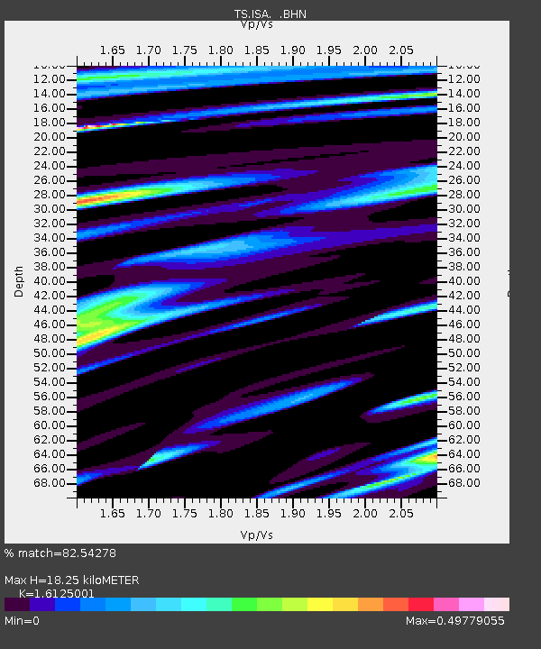
| Estimated Moho Depth: |
18.25 km |
| Estimated Crust Vp/Vs: |
1.61 |
| Assumed Crust Vp: |
6.1 km/s |
| Estimated Crust Vs: |
3.783 km/s |
| Estimated Crust Poisson's Ratio: |
0.19 |
|
| Radial Match: |
82.54278 % |
| Radial Bump: |
400 |
| Transverse Match: |
70.41838 % |
| Transverse Bump: |
400 |
| SOD ConfigId: |
16938 |
| Insert Time: |
2010-02-26 14:22:49.874 +0000 |
| GWidth: |
2.5 |
| Max Bumps: |
400 |
| Tol: |
0.001 |
|

Signal To Noise
| Channel | StoN | STA | LTA |
| TS:ISA: :BHN:19920811T15:26:26.180029Z | 1.4864607 | 1.774004E-7 | 1.1934415E-7 |
| TS:ISA: :BHE:19920811T15:26:26.180029Z | 1.4406782 | 1.00141946E-7 | 6.951028E-8 |
| TS:ISA: :BHZ:19920811T15:26:26.180029Z | 4.0465713 | 3.9990223E-7 | 9.8824955E-8 |
| Arrivals |
| Ps | 1.9 SECOND |
| PpPs | 7.6 SECOND |
| PsPs/PpSs | 9.5 SECOND |


