You are here: Home > Network List > TA - USArray Transportable Network (new EarthScope stations) Stations List
> Station S09A Goldfield, NV, USA > Earthquake Result Viewer
S09A Goldfield, NV, USA - Earthquake Result Viewer
| Earthquake location: |
Eastern Siberia, Russia |
| Earthquake latitude/longitude: |
60.8/165.7 |
| Earthquake time(UTC): |
2006/05/22 (142) 11:12:00 GMT |
| Earthquake Depth: |
16 km |
| Earthquake Magnitude: |
6.0 MB, 6.7 MS, 6.6 MW, 6.5 MW |
| Earthquake Catalog/Contributor: |
WHDF/NEIC |
|
| Network: |
TA USArray Transportable Network (new EarthScope stations) |
| Station: |
S09A Goldfield, NV, USA |
| Lat/Lon: |
37.72 N/117.23 W |
| Elevation: |
1768 m |
|
| Distance: |
51.8 deg |
| Az: |
79.437 deg |
| Baz: |
322.52 deg |
| Ray Param: |
0.06714638 |
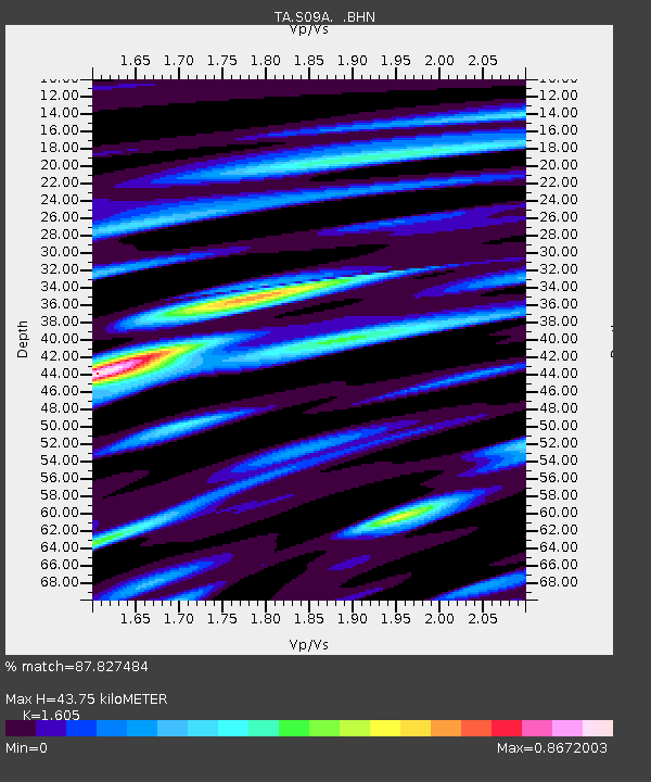
| Estimated Moho Depth: |
43.75 km |
| Estimated Crust Vp/Vs: |
1.61 |
| Assumed Crust Vp: |
6.279 km/s |
| Estimated Crust Vs: |
3.912 km/s |
| Estimated Crust Poisson's Ratio: |
0.18 |
|
| Radial Match: |
87.827484 % |
| Radial Bump: |
400 |
| Transverse Match: |
60.910713 % |
| Transverse Bump: |
400 |
| SOD ConfigId: |
2669 |
| Insert Time: |
2010-03-07 02:40:25.001 +0000 |
| GWidth: |
2.5 |
| Max Bumps: |
400 |
| Tol: |
0.001 |
|

Signal To Noise
| Channel | StoN | STA | LTA |
| TA:S09A: :BHN:20060522T11:20:36.450007Z | 3.1289425 | 4.3321728E-7 | 1.3845485E-7 |
| TA:S09A: :BHE:20060522T11:20:36.450007Z | 2.5592043 | 2.0828236E-7 | 8.138559E-8 |
| TA:S09A: :BHZ:20060522T11:20:36.450007Z | 11.714775 | 9.822468E-7 | 8.3846835E-8 |
| Arrivals |
| Ps | 4.5 SECOND |
| PpPs | 17 SECOND |
| PsPs/PpSs | 22 SECOND |


