You are here: Home > Network List > TA - USArray Transportable Network (new EarthScope stations) Stations List
> Station S09A Goldfield, NV, USA > Earthquake Result Viewer
S09A Goldfield, NV, USA - Earthquake Result Viewer
| Earthquake location: |
Panama-Costa Rica Border Region |
| Earthquake latitude/longitude: |
8.2/-82.9 |
| Earthquake time(UTC): |
2006/05/01 (121) 07:47:59 GMT |
| Earthquake Depth: |
13 km |
| Earthquake Magnitude: |
5.1 MB, 5.6 MS, 5.9 MW, 5.9 MW |
| Earthquake Catalog/Contributor: |
WHDF/NEIC |
|
| Network: |
TA USArray Transportable Network (new EarthScope stations) |
| Station: |
S09A Goldfield, NV, USA |
| Lat/Lon: |
37.72 N/117.23 W |
| Elevation: |
1768 m |
|
| Distance: |
42.8 deg |
| Az: |
318.79 deg |
| Baz: |
124.66 deg |
| Ray Param: |
0.072970904 |
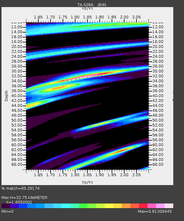
| Estimated Moho Depth: |
32.75 km |
| Estimated Crust Vp/Vs: |
1.81 |
| Assumed Crust Vp: |
6.279 km/s |
| Estimated Crust Vs: |
3.478 km/s |
| Estimated Crust Poisson's Ratio: |
0.28 |
|
| Radial Match: |
85.28174 % |
| Radial Bump: |
400 |
| Transverse Match: |
65.13925 % |
| Transverse Bump: |
400 |
| SOD ConfigId: |
2669 |
| Insert Time: |
2010-03-07 02:40:35.245 +0000 |
| GWidth: |
2.5 |
| Max Bumps: |
400 |
| Tol: |
0.001 |
|

Signal To Noise
| Channel | StoN | STA | LTA |
| TA:S09A: :BHN:20060501T07:55:26.07399Z | 1.965888 | 2.2096184E-7 | 1.1239798E-7 |
| TA:S09A: :BHE:20060501T07:55:26.07399Z | 2.6538162 | 3.0702793E-7 | 1.15692984E-7 |
| TA:S09A: :BHZ:20060501T07:55:26.07399Z | 5.253894 | 7.7534565E-7 | 1.4757542E-7 |
| Arrivals |
| Ps | 4.5 SECOND |
| PpPs | 14 SECOND |
| PsPs/PpSs | 18 SECOND |


