You are here: Home > Network List > TA - USArray Transportable Network (new EarthScope stations) Stations List
> Station S09A Goldfield, NV, USA > Earthquake Result Viewer
S09A Goldfield, NV, USA - Earthquake Result Viewer
| Earthquake location: |
Kuril Islands |
| Earthquake latitude/longitude: |
45.8/150.1 |
| Earthquake time(UTC): |
2007/09/03 (246) 16:14:53 GMT |
| Earthquake Depth: |
94 km |
| Earthquake Magnitude: |
6.3 MB, 6.2 MW, 6.2 ME |
| Earthquake Catalog/Contributor: |
WHDF/NEIC |
|
| Network: |
TA USArray Transportable Network (new EarthScope stations) |
| Station: |
S09A Goldfield, NV, USA |
| Lat/Lon: |
37.72 N/117.23 W |
| Elevation: |
1768 m |
|
| Distance: |
65.8 deg |
| Az: |
60.244 deg |
| Baz: |
310.056 deg |
| Ray Param: |
0.05776842 |
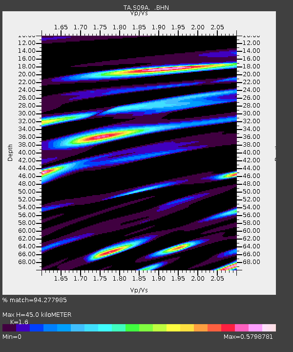
| Estimated Moho Depth: |
45.0 km |
| Estimated Crust Vp/Vs: |
1.60 |
| Assumed Crust Vp: |
6.279 km/s |
| Estimated Crust Vs: |
3.924 km/s |
| Estimated Crust Poisson's Ratio: |
0.18 |
|
| Radial Match: |
94.277985 % |
| Radial Bump: |
345 |
| Transverse Match: |
77.18626 % |
| Transverse Bump: |
400 |
| SOD ConfigId: |
2564 |
| Insert Time: |
2010-03-07 02:40:51.870 +0000 |
| GWidth: |
2.5 |
| Max Bumps: |
400 |
| Tol: |
0.001 |
|
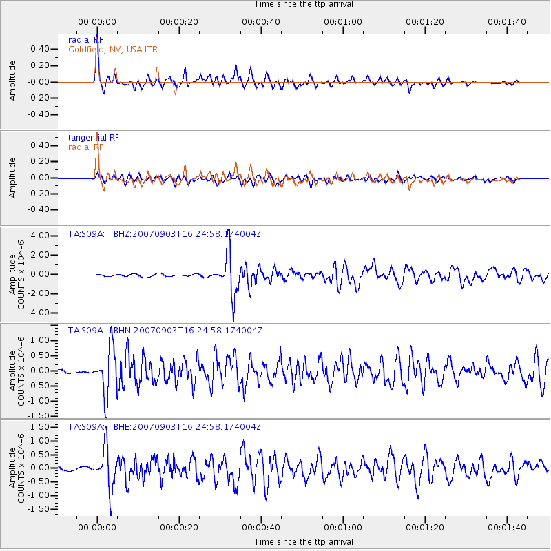
Signal To Noise
| Channel | StoN | STA | LTA |
| TA:S09A: :BHN:20070903T16:24:58.174004Z | 9.102847 | 8.078191E-7 | 8.874357E-8 |
| TA:S09A: :BHE:20070903T16:24:58.174004Z | 11.174514 | 7.780328E-7 | 6.9625656E-8 |
| TA:S09A: :BHZ:20070903T16:24:58.174004Z | 18.029821 | 2.3198645E-6 | 1.2866819E-7 |
| Arrivals |
| Ps | 4.5 SECOND |
| PpPs | 18 SECOND |
| PsPs/PpSs | 22 SECOND |


