You are here: Home > Network List > TA - USArray Transportable Network (new EarthScope stations) Stations List
> Station S09A Goldfield, NV, USA > Earthquake Result Viewer
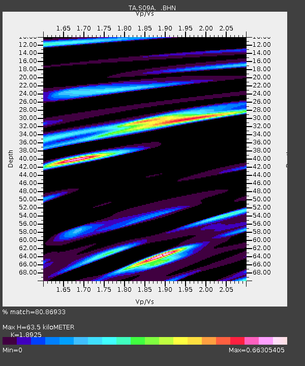
S09A Goldfield, NV, USA - Earthquake Result Viewer
| Earthquake location: |
Near Coast Of Peru |
| Earthquake latitude/longitude: |
-13.6/-76.6 |
| Earthquake time(UTC): |
2007/08/19 (231) 01:22:40 GMT |
| Earthquake Depth: |
26 km |
| Earthquake Magnitude: |
5.9 MB, 5.4 MS, 5.8 MW, 5.5 ML |
| Earthquake Catalog/Contributor: |
WHDF/NEIC |
|
| Network: |
TA USArray Transportable Network (new EarthScope stations) |
| Station: |
S09A Goldfield, NV, USA |
| Lat/Lon: |
37.72 N/117.23 W |
| Elevation: |
1768 m |
|
| Distance: |
63.7 deg |
| Az: |
324.86 deg |
| Baz: |
135.114 deg |
| Ray Param: |
0.059349786 |
| Estimated Moho Depth: |
63.5 km |
| Estimated Crust Vp/Vs: |
1.89 |
| Assumed Crust Vp: |
6.279 km/s |
| Estimated Crust Vs: |
3.318 km/s |
| Estimated Crust Poisson's Ratio: |
0.31 |
|
| Radial Match: |
80.86933 % |
| Radial Bump: |
400 |
| Transverse Match: |
70.780426 % |
| Transverse Bump: |
400 |
| SOD ConfigId: |
2564 |
| Insert Time: |
2010-03-07 02:40:55.834 +0000 |
| GWidth: |
2.5 |
| Max Bumps: |
400 |
| Tol: |
0.001 |
|

Signal To Noise
| Channel | StoN | STA | LTA |
| TA:S09A: :BHN:20070819T01:32:38.975002Z | 1.349385 | 7.149518E-8 | 5.298353E-8 |
| TA:S09A: :BHE:20070819T01:32:38.975002Z | 2.0554333 | 1.2327435E-7 | 5.997488E-8 |
| TA:S09A: :BHZ:20070819T01:32:38.975002Z | 4.3267856 | 2.58197E-7 | 5.967409E-8 |
| Arrivals |
| Ps | 9.4 SECOND |
| PpPs | 28 SECOND |
| PsPs/PpSs | 38 SECOND |


