You are here: Home > Network List > TA - USArray Transportable Network (new EarthScope stations) Stations List
> Station S09A Goldfield, NV, USA > Earthquake Result Viewer
S09A Goldfield, NV, USA - Earthquake Result Viewer
| Earthquake location: |
Jujuy Province, Argentina |
| Earthquake latitude/longitude: |
-22.2/-65.8 |
| Earthquake time(UTC): |
2007/07/21 (202) 15:34:52 GMT |
| Earthquake Depth: |
290 km |
| Earthquake Magnitude: |
5.8 MB, 6.4 MW, 6.3 MW |
| Earthquake Catalog/Contributor: |
WHDF/NEIC |
|
| Network: |
TA USArray Transportable Network (new EarthScope stations) |
| Station: |
S09A Goldfield, NV, USA |
| Lat/Lon: |
37.72 N/117.23 W |
| Elevation: |
1768 m |
|
| Distance: |
76.7 deg |
| Az: |
320.419 deg |
| Baz: |
131.846 deg |
| Ray Param: |
0.050016824 |
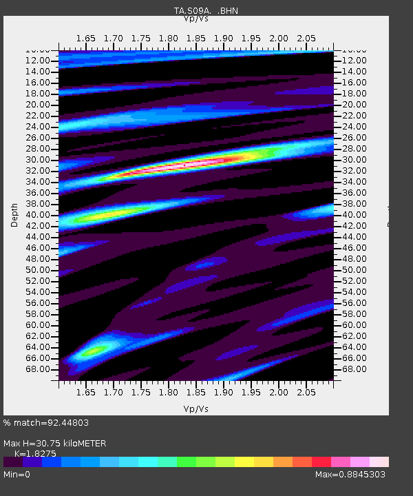
| Estimated Moho Depth: |
30.75 km |
| Estimated Crust Vp/Vs: |
1.83 |
| Assumed Crust Vp: |
6.279 km/s |
| Estimated Crust Vs: |
3.436 km/s |
| Estimated Crust Poisson's Ratio: |
0.29 |
|
| Radial Match: |
92.44803 % |
| Radial Bump: |
367 |
| Transverse Match: |
65.318634 % |
| Transverse Bump: |
400 |
| SOD ConfigId: |
2564 |
| Insert Time: |
2010-03-07 02:41:10.223 +0000 |
| GWidth: |
2.5 |
| Max Bumps: |
400 |
| Tol: |
0.001 |
|
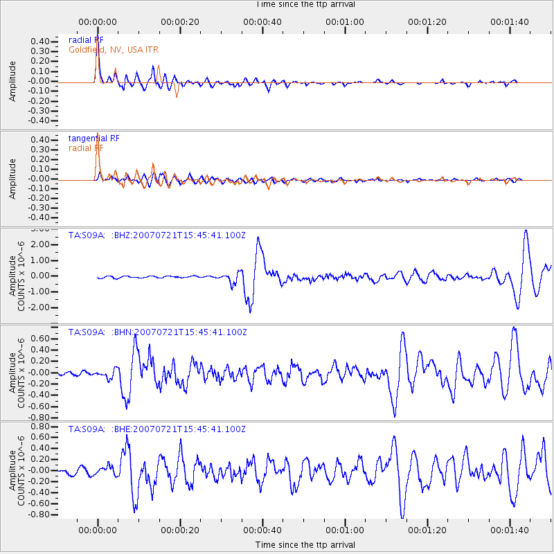
Signal To Noise
| Channel | StoN | STA | LTA |
| TA:S09A: :BHN:20070721T15:45:41.100Z | 2.3848214 | 7.321605E-8 | 3.070085E-8 |
| TA:S09A: :BHE:20070721T15:45:41.100Z | 1.6602391 | 7.710472E-8 | 4.6441937E-8 |
| TA:S09A: :BHZ:20070721T15:45:41.100Z | 5.678822 | 3.233118E-7 | 5.6932905E-8 |
| Arrivals |
| Ps | 4.2 SECOND |
| PpPs | 13 SECOND |
| PsPs/PpSs | 18 SECOND |


