You are here: Home > Network List > BX - Botswana Seismological Network Stations List
> Station LPHEP Lephepe > Earthquake Result Viewer
LPHEP Lephepe - Earthquake Result Viewer
| Earthquake location: |
Southwest Of Sumatra, Indonesia |
| Earthquake latitude/longitude: |
-7.3/104.8 |
| Earthquake time(UTC): |
2019/08/02 (214) 12:03:26 GMT |
| Earthquake Depth: |
43 km |
| Earthquake Magnitude: |
6.8 Mww |
| Earthquake Catalog/Contributor: |
NEIC PDE/us |
|
| Network: |
BX Botswana Seismological Network |
| Station: |
LPHEP Lephepe |
| Lat/Lon: |
23.36 S/25.86 E |
| Elevation: |
1020 m |
|
| Distance: |
77.0 deg |
| Az: |
247.751 deg |
| Baz: |
92.402 deg |
| Ray Param: |
0.05052813 |
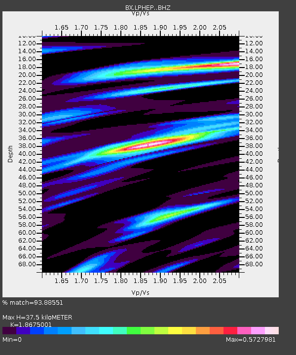
| Estimated Moho Depth: |
37.5 km |
| Estimated Crust Vp/Vs: |
1.87 |
| Assumed Crust Vp: |
6.459 km/s |
| Estimated Crust Vs: |
3.459 km/s |
| Estimated Crust Poisson's Ratio: |
0.30 |
|
| Radial Match: |
93.88551 % |
| Radial Bump: |
271 |
| Transverse Match: |
86.671524 % |
| Transverse Bump: |
383 |
| SOD ConfigId: |
19053131 |
| Insert Time: |
2019-08-16 12:05:49.925 +0000 |
| GWidth: |
2.5 |
| Max Bumps: |
400 |
| Tol: |
0.001 |
|

Signal To Noise
| Channel | StoN | STA | LTA |
| BX:LPHEP: :BHZ:20190802T12:14:44.206971Z | 6.271383 | 2.1628782E-6 | 3.4488062E-7 |
| BX:LPHEP: :BHN:20190802T12:14:44.206971Z | 1.604165 | 3.0736558E-7 | 1.9160471E-7 |
| BX:LPHEP: :BHE:20190802T12:14:44.206971Z | 3.8281088 | 8.0076427E-7 | 2.0918013E-7 |
| Arrivals |
| Ps | 5.2 SECOND |
| PpPs | 16 SECOND |
| PsPs/PpSs | 21 SECOND |


