You are here: Home > Network List > TA - USArray Transportable Network (new EarthScope stations) Stations List
> Station S09A Goldfield, NV, USA > Earthquake Result Viewer
S09A Goldfield, NV, USA - Earthquake Result Viewer

| Earthquake location: |
Solomon Islands |
| Earthquake latitude/longitude: |
-7.3/155.6 |
| Earthquake time(UTC): |
2007/04/01 (091) 21:45:37 GMT |
| Earthquake Depth: |
10 km |
| Earthquake Magnitude: |
5.7 MB |
| Earthquake Catalog/Contributor: |
WHDF/NEIC |
|
| Network: |
TA USArray Transportable Network (new EarthScope stations) |
| Station: |
S09A Goldfield, NV, USA |
| Lat/Lon: |
37.72 N/117.23 W |
| Elevation: |
1768 m |
|
| Distance: |
92.2 deg |
| Az: |
52.422 deg |
| Baz: |
262.482 deg |
| Ray Param: |
0.041499253 |
| Estimated Moho Depth: |
61.25 km |
| Estimated Crust Vp/Vs: |
1.64 |
| Assumed Crust Vp: |
6.279 km/s |
| Estimated Crust Vs: |
3.817 km/s |
| Estimated Crust Poisson's Ratio: |
0.21 |
|
| Radial Match: |
91.96676 % |
| Radial Bump: |
400 |
| Transverse Match: |
76.82831 % |
| Transverse Bump: |
346 |
| SOD ConfigId: |
2564 |
| Insert Time: |
2010-03-07 02:41:30.893 +0000 |
| GWidth: |
2.5 |
| Max Bumps: |
400 |
| Tol: |
0.001 |
|
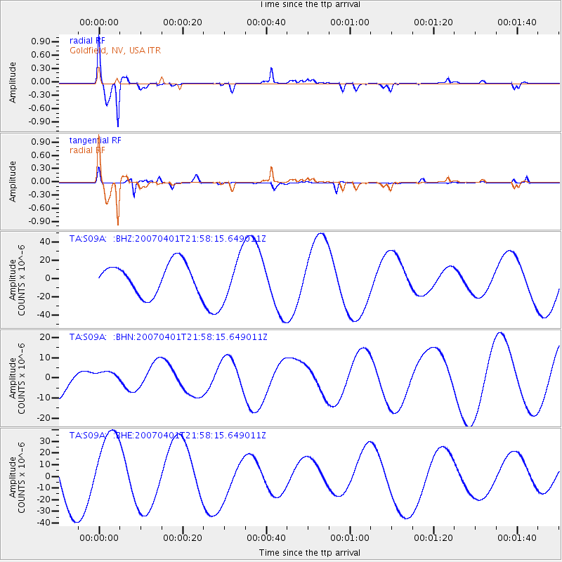
Signal To Noise
| Channel | StoN | STA | LTA |
| TA:S09A: :BHN:20070401T21:58:15.649011Z | 0.665283 | 4.6179966E-6 | 6.9414014E-6 |
| TA:S09A: :BHE:20070401T21:58:15.649011Z | 1.3583909 | 3.2444714E-5 | 2.3884666E-5 |
| TA:S09A: :BHZ:20070401T21:58:15.649011Z | 1.4877826 | 2.456711E-5 | 1.6512568E-5 |
| Arrivals |
| Ps | 6.4 SECOND |
| PpPs | 25 SECOND |
| PsPs/PpSs | 32 SECOND |


