You are here: Home > Network List > G - GEOSCOPE Stations List
> Station FOMA Nahampoana reservation, Fort Dauphin, Madagascar > Earthquake Result Viewer
FOMA Nahampoana reservation, Fort Dauphin, Madagascar - Earthquake Result Viewer
| Earthquake location: |
Southwest Of Sumatra, Indonesia |
| Earthquake latitude/longitude: |
-7.3/104.8 |
| Earthquake time(UTC): |
2019/08/02 (214) 12:03:26 GMT |
| Earthquake Depth: |
43 km |
| Earthquake Magnitude: |
6.8 Mww |
| Earthquake Catalog/Contributor: |
NEIC PDE/us |
|
| Network: |
G GEOSCOPE |
| Station: |
FOMA Nahampoana reservation, Fort Dauphin, Madagascar |
| Lat/Lon: |
24.98 S/46.98 E |
| Elevation: |
26 m |
|
| Distance: |
57.8 deg |
| Az: |
245.158 deg |
| Baz: |
82.711 deg |
| Ray Param: |
0.06314595 |
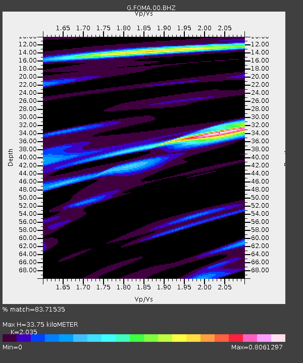
| Estimated Moho Depth: |
33.75 km |
| Estimated Crust Vp/Vs: |
2.04 |
| Assumed Crust Vp: |
6.183 km/s |
| Estimated Crust Vs: |
3.038 km/s |
| Estimated Crust Poisson's Ratio: |
0.34 |
|
| Radial Match: |
83.71535 % |
| Radial Bump: |
400 |
| Transverse Match: |
70.027466 % |
| Transverse Bump: |
372 |
| SOD ConfigId: |
19053131 |
| Insert Time: |
2019-08-16 12:06:00.448 +0000 |
| GWidth: |
2.5 |
| Max Bumps: |
400 |
| Tol: |
0.001 |
|

Signal To Noise
| Channel | StoN | STA | LTA |
| G:FOMA:00:BHZ:20190802T12:12:43.299012Z | 4.151963 | 2.4052536E-6 | 5.7930504E-7 |
| G:FOMA:00:BHN:20190802T12:12:43.299012Z | 0.6263822 | 4.082973E-7 | 6.5183417E-7 |
| G:FOMA:00:BHE:20190802T12:12:43.299012Z | 1.9992819 | 1.0792636E-6 | 5.3982563E-7 |
| Arrivals |
| Ps | 5.9 SECOND |
| PpPs | 16 SECOND |
| PsPs/PpSs | 22 SECOND |


