You are here: Home > Network List > NM - Cooperative New Madrid Seismic Network Stations List
> Station UTMT Martin, TN > Earthquake Result Viewer
UTMT Martin, TN - Earthquake Result Viewer
| Earthquake location: |
Southern Chile |
| Earthquake latitude/longitude: |
-43.3/-74.5 |
| Earthquake time(UTC): |
2016/12/25 (360) 14:22:28 GMT |
| Earthquake Depth: |
15 km |
| Earthquake Magnitude: |
7.7 Mi |
| Earthquake Catalog/Contributor: |
NEIC PDE/at |
|
| Network: |
NM Cooperative New Madrid Seismic Network |
| Station: |
UTMT Martin, TN |
| Lat/Lon: |
36.35 N/88.86 W |
| Elevation: |
110 m |
|
| Distance: |
80.3 deg |
| Az: |
348.279 deg |
| Baz: |
169.414 deg |
| Ray Param: |
0.04832983 |
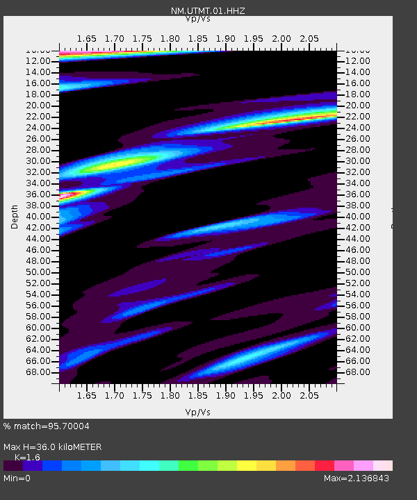
| Estimated Moho Depth: |
36.0 km |
| Estimated Crust Vp/Vs: |
1.60 |
| Assumed Crust Vp: |
6.444 km/s |
| Estimated Crust Vs: |
4.027 km/s |
| Estimated Crust Poisson's Ratio: |
0.18 |
|
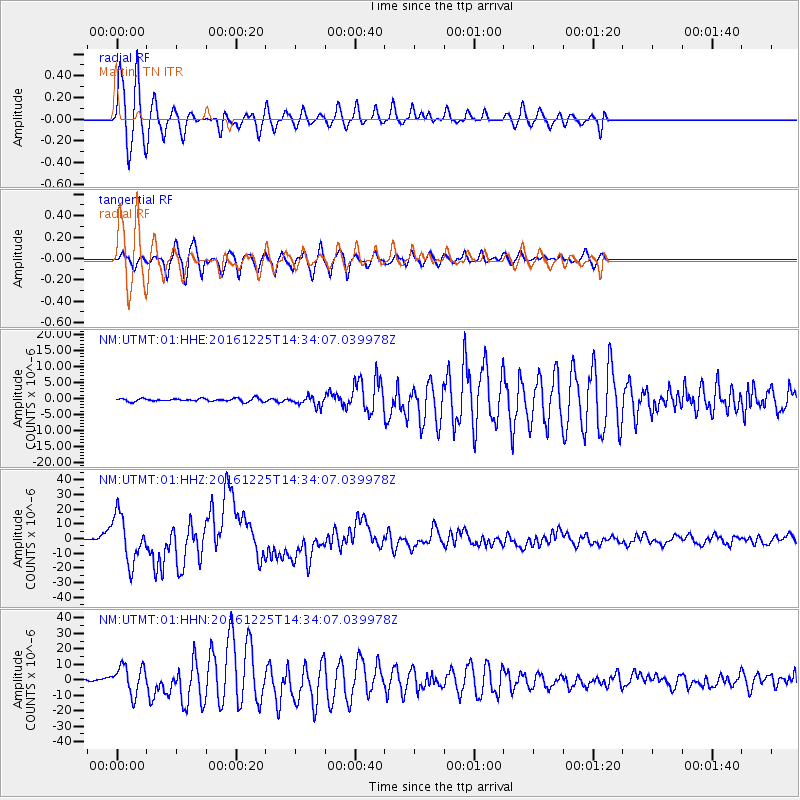
| Radial Match: |
95.70004 % |
| Radial Bump: |
358 |
| Transverse Match: |
93.17564 % |
| Transverse Bump: |
363 |
| SOD ConfigId: |
1894071 |
| Insert Time: |
2017-01-08 14:31:21.218 +0000 |
| GWidth: |
2.5 |
| Max Bumps: |
400 |
| Tol: |
0.001 |
|
Signal To Noise
| Channel | StoN | STA | LTA |
| NM:UTMT:01:HHZ:20161225T14:34:07.039978Z | 48.41764 | 1.5802272E-5 | 3.2637428E-7 |
| NM:UTMT:01:HHN:20161225T14:34:07.039978Z | 9.090846 | 9.257547E-6 | 1.0183372E-6 |
| NM:UTMT:01:HHE:20161225T14:34:07.039978Z | 3.2367146 | 1.5125555E-6 | 4.67312E-7 |
| Arrivals |
| Ps | 3.5 SECOND |
| PpPs | 14 SECOND |
| PsPs/PpSs | 18 SECOND |


