You are here: Home > Network List > TA - USArray Transportable Network (new EarthScope stations) Stations List
> Station S09A Goldfield, NV, USA > Earthquake Result Viewer
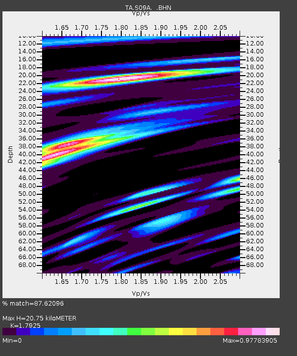
S09A Goldfield, NV, USA - Earthquake Result Viewer
| Earthquake location: |
Andreanof Islands, Aleutian Is. |
| Earthquake latitude/longitude: |
52.2/-178.7 |
| Earthquake time(UTC): |
2008/03/22 (082) 21:24:11 GMT |
| Earthquake Depth: |
132 km |
| Earthquake Magnitude: |
5.8 MB, 6.2 MW, 6.1 MW |
| Earthquake Catalog/Contributor: |
WHDF/NEIC |
|
| Network: |
TA USArray Transportable Network (new EarthScope stations) |
| Station: |
S09A Goldfield, NV, USA |
| Lat/Lon: |
37.72 N/117.23 W |
| Elevation: |
1768 m |
|
| Distance: |
44.5 deg |
| Az: |
83.694 deg |
| Baz: |
309.475 deg |
| Ray Param: |
0.07139851 |
| Estimated Moho Depth: |
20.75 km |
| Estimated Crust Vp/Vs: |
1.79 |
| Assumed Crust Vp: |
6.279 km/s |
| Estimated Crust Vs: |
3.503 km/s |
| Estimated Crust Poisson's Ratio: |
0.27 |
|
| Radial Match: |
87.62096 % |
| Radial Bump: |
400 |
| Transverse Match: |
77.39249 % |
| Transverse Bump: |
400 |
| SOD ConfigId: |
2564 |
| Insert Time: |
2010-03-07 02:41:42.772 +0000 |
| GWidth: |
2.5 |
| Max Bumps: |
400 |
| Tol: |
0.001 |
|

Signal To Noise
| Channel | StoN | STA | LTA |
| TA:S09A: :BHN:20080322T21:31:39.150005Z | 7.464157 | 1.3885834E-6 | 1.8603352E-7 |
| TA:S09A: :BHE:20080322T21:31:39.150005Z | 9.376351 | 1.3096313E-6 | 1.3967389E-7 |
| TA:S09A: :BHZ:20080322T21:31:39.150005Z | 19.24534 | 3.3927874E-6 | 1.7629138E-7 |
| Arrivals |
| Ps | 2.8 SECOND |
| PpPs | 8.7 SECOND |
| PsPs/PpSs | 11 SECOND |


