You are here: Home > Network List > TA - USArray Transportable Network (new EarthScope stations) Stations List
> Station S09A Goldfield, NV, USA > Earthquake Result Viewer
S09A Goldfield, NV, USA - Earthquake Result Viewer
| Earthquake location: |
Kuril Islands |
| Earthquake latitude/longitude: |
46.4/153.2 |
| Earthquake time(UTC): |
2008/03/03 (063) 09:31:02 GMT |
| Earthquake Depth: |
10 km |
| Earthquake Magnitude: |
6.2 MB, 6.5 MS, 6.5 MW, 6.5 MW |
| Earthquake Catalog/Contributor: |
WHDF/NEIC |
|
| Network: |
TA USArray Transportable Network (new EarthScope stations) |
| Station: |
S09A Goldfield, NV, USA |
| Lat/Lon: |
37.72 N/117.23 W |
| Elevation: |
1768 m |
|
| Distance: |
63.7 deg |
| Az: |
62.226 deg |
| Baz: |
309.456 deg |
| Ray Param: |
0.059433352 |
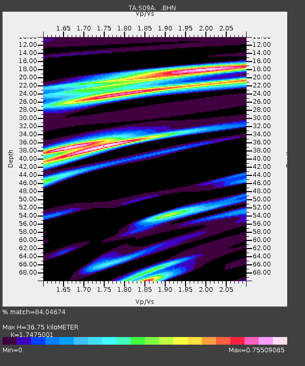
| Estimated Moho Depth: |
36.75 km |
| Estimated Crust Vp/Vs: |
1.75 |
| Assumed Crust Vp: |
6.279 km/s |
| Estimated Crust Vs: |
3.593 km/s |
| Estimated Crust Poisson's Ratio: |
0.26 |
|
| Radial Match: |
84.04674 % |
| Radial Bump: |
306 |
| Transverse Match: |
71.96675 % |
| Transverse Bump: |
400 |
| SOD ConfigId: |
2564 |
| Insert Time: |
2010-03-07 02:41:44.698 +0000 |
| GWidth: |
2.5 |
| Max Bumps: |
400 |
| Tol: |
0.001 |
|

Signal To Noise
| Channel | StoN | STA | LTA |
| TA:S09A: :BHN:20080303T09:41:02.650024Z | 0.7733772 | 1.4980095E-7 | 1.9369715E-7 |
| TA:S09A: :BHE:20080303T09:41:02.650024Z | 1.1138395 | 1.6571374E-7 | 1.4877705E-7 |
| TA:S09A: :BHZ:20080303T09:41:02.650024Z | 2.9368865 | 5.480505E-7 | 1.8660936E-7 |
| Arrivals |
| Ps | 4.6 SECOND |
| PpPs | 15 SECOND |
| PsPs/PpSs | 20 SECOND |


