You are here: Home > Network List > TA - USArray Transportable Network (new EarthScope stations) Stations List
> Station S09A Goldfield, NV, USA > Earthquake Result Viewer
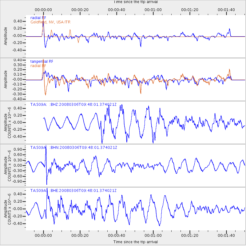
S09A Goldfield, NV, USA - Earthquake Result Viewer
*The percent match for this event was below the threshold and hence no stack was calculated.
| Earthquake location: |
Kamchatka Peninsula, Russia |
| Earthquake latitude/longitude: |
51.5/156.5 |
| Earthquake time(UTC): |
2008/03/06 (066) 09:38:43 GMT |
| Earthquake Depth: |
134 km |
| Earthquake Magnitude: |
5.6 MB, 5.5 MW, 5.5 MW |
| Earthquake Catalog/Contributor: |
WHDF/NEIC |
|
| Network: |
TA USArray Transportable Network (new EarthScope stations) |
| Station: |
S09A Goldfield, NV, USA |
| Lat/Lon: |
37.72 N/117.23 W |
| Elevation: |
1768 m |
|
| Distance: |
59.4 deg |
| Az: |
66.75 deg |
| Baz: |
313.62 deg |
| Ray Param: |
$rayparam |
*The percent match for this event was below the threshold and hence was not used in the summary stack. |
|
| Radial Match: |
67.23569 % |
| Radial Bump: |
400 |
| Transverse Match: |
62.100716 % |
| Transverse Bump: |
400 |
| SOD ConfigId: |
2504 |
| Insert Time: |
2010-03-07 02:41:48.171 +0000 |
| GWidth: |
2.5 |
| Max Bumps: |
400 |
| Tol: |
0.001 |
|
Signal To Noise
| Channel | StoN | STA | LTA |
| TA:S09A: :BHN:20080306T09:48:01.374021Z | 2.4094079 | 4.153979E-7 | 1.7240664E-7 |
| TA:S09A: :BHE:20080306T09:48:01.374021Z | 1.3366047 | 2.3450265E-7 | 1.7544652E-7 |
| TA:S09A: :BHZ:20080306T09:48:01.374021Z | 2.0166323 | 2.608137E-7 | 1.2933131E-7 |
| Arrivals |
| Ps | |
| PpPs | |
| PsPs/PpSs | |


