You are here: Home > Network List > JP - Japan Meteorological Agency Seismic Network Stations List
> Station JWT Kyoto Wachi > Earthquake Result Viewer
JWT Kyoto Wachi - Earthquake Result Viewer
| Earthquake location: |
Southwest Of Sumatra, Indonesia |
| Earthquake latitude/longitude: |
-7.3/104.8 |
| Earthquake time(UTC): |
2019/08/02 (214) 12:03:26 GMT |
| Earthquake Depth: |
43 km |
| Earthquake Magnitude: |
6.8 Mww |
| Earthquake Catalog/Contributor: |
NEIC PDE/us |
|
| Network: |
JP Japan Meteorological Agency Seismic Network |
| Station: |
JWT Kyoto Wachi |
| Lat/Lon: |
35.29 N/135.40 E |
| Elevation: |
172 m |
|
| Distance: |
51.2 deg |
| Az: |
32.275 deg |
| Baz: |
220.354 deg |
| Ray Param: |
0.06744717 |
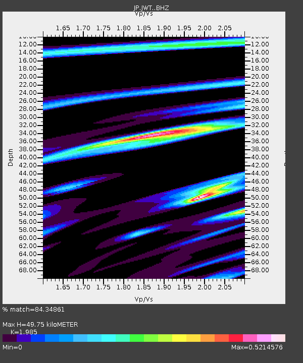
| Estimated Moho Depth: |
49.75 km |
| Estimated Crust Vp/Vs: |
1.99 |
| Assumed Crust Vp: |
6.468 km/s |
| Estimated Crust Vs: |
3.258 km/s |
| Estimated Crust Poisson's Ratio: |
0.33 |
|
| Radial Match: |
84.34861 % |
| Radial Bump: |
255 |
| Transverse Match: |
60.29205 % |
| Transverse Bump: |
293 |
| SOD ConfigId: |
19053131 |
| Insert Time: |
2019-08-16 12:06:40.211 +0000 |
| GWidth: |
2.5 |
| Max Bumps: |
400 |
| Tol: |
0.001 |
|

Signal To Noise
| Channel | StoN | STA | LTA |
| JP:JWT: :BHZ:20190802T12:11:55.500001Z | 1.2327775 | 1.1171451E-8 | 9.062018E-9 |
| JP:JWT: :BHN:20190802T12:11:55.500001Z | 0.98055404 | 2.4330387E-8 | 2.4812898E-8 |
| JP:JWT: :BHE:20190802T12:11:55.500001Z | 1.2778344 | 1.0718653E-8 | 8.388139E-9 |
| Arrivals |
| Ps | 8.0 SECOND |
| PpPs | 22 SECOND |
| PsPs/PpSs | 30 SECOND |


