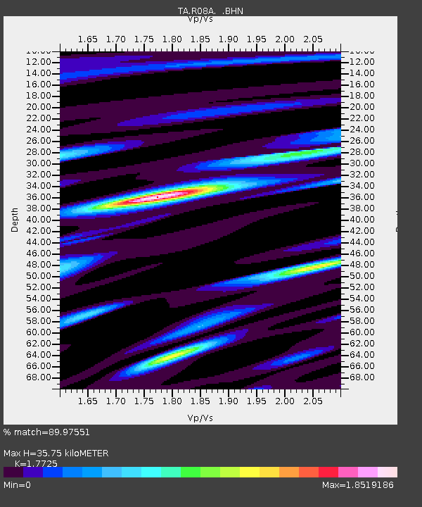
R08A Mina, NV, USA - Earthquake Result Viewer
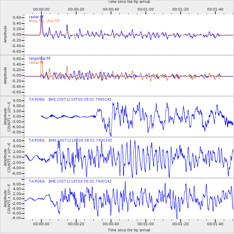
Earthquake location: Andreanof Islands, Aleutian Is.
Earthquake latitude/longitude: 51.4/-179.5
Earthquake time(UTC): 2007/12/19 (353) 09:30:27 GMT
Earthquake Depth: 29 km
Earthquake Magnitude: 6.4 MB, 7.1 MS, 7.1 MW, 7.0 MW
Earthquake Catalog/Contributor: WHDF/NEIC
Network: TA USArray Transportable Network (new EarthScope stations)
Station: R08A Mina, NV, USA
Lat/Lon: 38.35 N/118.11 W
Elevation: 1420 m
Distance: 44.2 deg
Az: 82.223 deg
Baz: 307.812 deg
Ray Param: 0.07202547
Estimated Moho Depth: 35.75 km
Estimated Crust Vp/Vs: 1.77
Assumed Crust Vp: 6.279 km/s
Estimated Crust Vs: 3.542 km/s
Estimated Crust Poisson's Ratio: 0.27
Radial Match: 89.97551 %
Radial Bump: 400
Transverse Match: 79.33367 %
Transverse Bump: 400
SOD ConfigId: 2564
Insert Time: 2010-03-07 02:41:54.952 +0000
GWidth: 2.5
Max Bumps: 400
Tol: 0.001

Signal To Noise

ChannelStoNSTALTA
TA:R08A: :BHN:20071219T09:38:02.749014Z1.92683918.5732444E-74.4493825E-7
TA:R08A: :BHE:20071219T09:38:02.749014Z3.92514471.108938E-62.8252157E-7
TA:R08A: :BHZ:20071219T09:38:02.749014Z5.89279272.476024E-64.2017837E-7
Arrivals
Ps4.7 SECOND
PpPs15 SECOND
PsPs/PpSs20 SECOND