You are here: Home > Network List > S1 - Australian Seismometers in Schools Stations List
> Station AUALC St Philip's College > Earthquake Result Viewer
AUALC St Philip's College - Earthquake Result Viewer
| Earthquake location: |
Southwest Of Sumatra, Indonesia |
| Earthquake latitude/longitude: |
-7.3/104.8 |
| Earthquake time(UTC): |
2019/08/02 (214) 12:03:26 GMT |
| Earthquake Depth: |
43 km |
| Earthquake Magnitude: |
6.8 Mww |
| Earthquake Catalog/Contributor: |
NEIC PDE/us |
|
| Network: |
S1 Australian Seismometers in Schools |
| Station: |
AUALC St Philip's College |
| Lat/Lon: |
23.69 S/133.88 E |
| Elevation: |
573 m |
|
| Distance: |
32.3 deg |
| Az: |
123.542 deg |
| Baz: |
295.585 deg |
| Ray Param: |
0.0786264 |
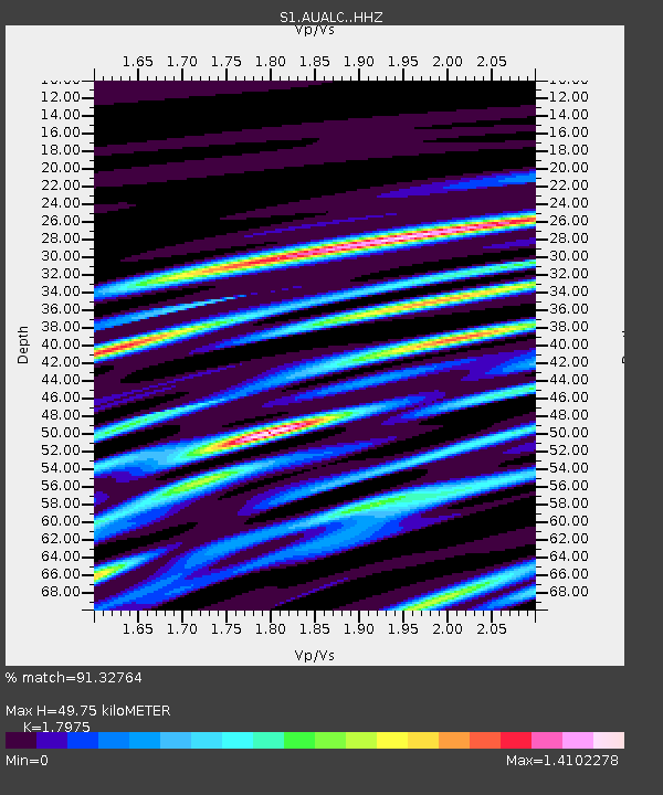
| Estimated Moho Depth: |
49.75 km |
| Estimated Crust Vp/Vs: |
1.80 |
| Assumed Crust Vp: |
6.518 km/s |
| Estimated Crust Vs: |
3.626 km/s |
| Estimated Crust Poisson's Ratio: |
0.28 |
|
| Radial Match: |
91.32764 % |
| Radial Bump: |
309 |
| Transverse Match: |
67.60164 % |
| Transverse Bump: |
400 |
| SOD ConfigId: |
19053131 |
| Insert Time: |
2019-08-16 12:07:29.319 +0000 |
| GWidth: |
2.5 |
| Max Bumps: |
400 |
| Tol: |
0.001 |
|

Signal To Noise
| Channel | StoN | STA | LTA |
| S1:AUALC: :HHZ:20190802T12:09:21.420014Z | 12.76267 | 4.28872E-6 | 3.360363E-7 |
| S1:AUALC: :HHN:20190802T12:09:21.420014Z | 4.7690167 | 1.3901501E-6 | 2.9149618E-7 |
| S1:AUALC: :HHE:20190802T12:09:21.420014Z | 10.106108 | 2.7280596E-6 | 2.6994167E-7 |
| Arrivals |
| Ps | 6.6 SECOND |
| PpPs | 20 SECOND |
| PsPs/PpSs | 26 SECOND |


