You are here: Home > Network List > TA - USArray Transportable Network (new EarthScope stations) Stations List
> Station R08A Mina, NV, USA > Earthquake Result Viewer
R08A Mina, NV, USA - Earthquake Result Viewer
| Earthquake location: |
Mariana Islands |
| Earthquake latitude/longitude: |
18.9/145.4 |
| Earthquake time(UTC): |
2007/10/31 (304) 03:30:17 GMT |
| Earthquake Depth: |
223 km |
| Earthquake Magnitude: |
6.2 MB, 7.2 MW, 7.2 MW |
| Earthquake Catalog/Contributor: |
WHDF/NEIC |
|
| Network: |
TA USArray Transportable Network (new EarthScope stations) |
| Station: |
R08A Mina, NV, USA |
| Lat/Lon: |
38.35 N/118.11 W |
| Elevation: |
1420 m |
|
| Distance: |
83.4 deg |
| Az: |
51.842 deg |
| Baz: |
288.769 deg |
| Ray Param: |
0.04564093 |
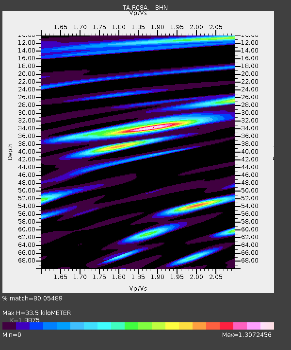
| Estimated Moho Depth: |
33.5 km |
| Estimated Crust Vp/Vs: |
1.89 |
| Assumed Crust Vp: |
6.279 km/s |
| Estimated Crust Vs: |
3.326 km/s |
| Estimated Crust Poisson's Ratio: |
0.30 |
|
| Radial Match: |
80.05489 % |
| Radial Bump: |
400 |
| Transverse Match: |
71.000916 % |
| Transverse Bump: |
400 |
| SOD ConfigId: |
2564 |
| Insert Time: |
2010-03-07 02:42:10.159 +0000 |
| GWidth: |
2.5 |
| Max Bumps: |
400 |
| Tol: |
0.001 |
|
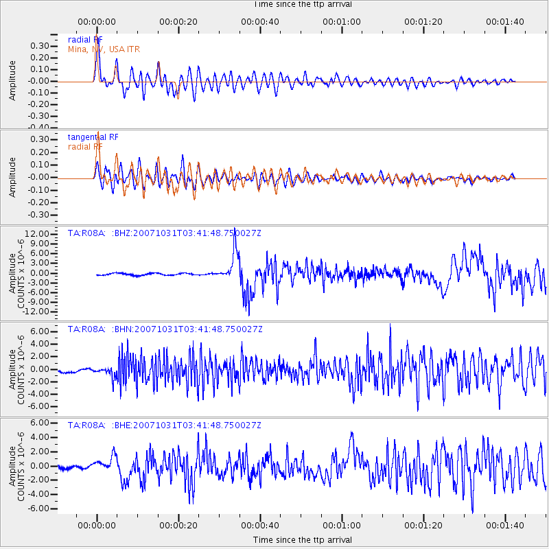
Signal To Noise
| Channel | StoN | STA | LTA |
| TA:R08A: :BHN:20071031T03:41:48.750027Z | 3.5776246 | 8.038184E-7 | 2.2467937E-7 |
| TA:R08A: :BHE:20071031T03:41:48.750027Z | 5.597505 | 1.1271104E-6 | 2.0135944E-7 |
| TA:R08A: :BHZ:20071031T03:41:48.750027Z | 15.187098 | 4.6953674E-6 | 3.0916817E-7 |
| Arrivals |
| Ps | 4.8 SECOND |
| PpPs | 15 SECOND |
| PsPs/PpSs | 20 SECOND |


