You are here: Home > Network List > TA - USArray Transportable Network (new EarthScope stations) Stations List
> Station B18K Kokolik River, AK, USA > Earthquake Result Viewer
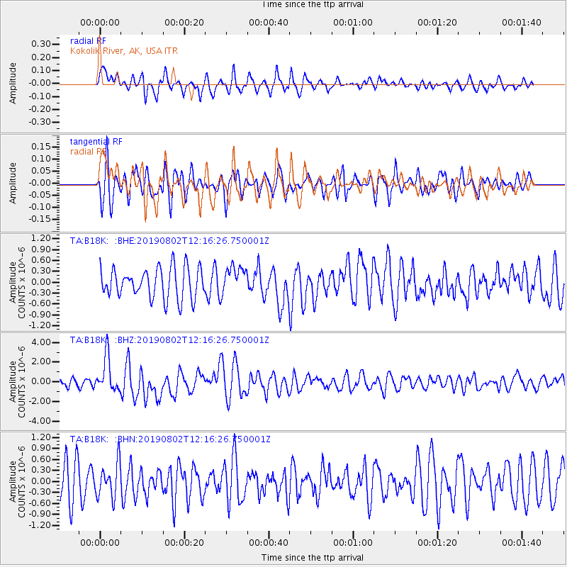
B18K Kokolik River, AK, USA - Earthquake Result Viewer
*The percent match for this event was below the threshold and hence no stack was calculated.
| Earthquake location: |
Southwest Of Sumatra, Indonesia |
| Earthquake latitude/longitude: |
-7.3/104.8 |
| Earthquake time(UTC): |
2019/08/02 (214) 12:03:26 GMT |
| Earthquake Depth: |
43 km |
| Earthquake Magnitude: |
6.8 Mww |
| Earthquake Catalog/Contributor: |
NEIC PDE/us |
|
| Network: |
TA USArray Transportable Network (new EarthScope stations) |
| Station: |
B18K Kokolik River, AK, USA |
| Lat/Lon: |
69.36 N/161.80 W |
| Elevation: |
222 m |
|
| Distance: |
98.0 deg |
| Az: |
20.937 deg |
| Baz: |
270.591 deg |
| Ray Param: |
$rayparam |
*The percent match for this event was below the threshold and hence was not used in the summary stack. |
|
| Radial Match: |
70.6461 % |
| Radial Bump: |
391 |
| Transverse Match: |
62.872913 % |
| Transverse Bump: |
400 |
| SOD ConfigId: |
19053131 |
| Insert Time: |
2019-08-16 12:07:46.583 +0000 |
| GWidth: |
2.5 |
| Max Bumps: |
400 |
| Tol: |
0.001 |
|
Signal To Noise
| Channel | StoN | STA | LTA |
| TA:B18K: :BHZ:20190802T12:16:26.750001Z | 3.7826269 | 1.8187619E-6 | 4.808198E-7 |
| TA:B18K: :BHN:20190802T12:16:26.750001Z | 1.0593549 | 4.812757E-7 | 4.5431017E-7 |
| TA:B18K: :BHE:20190802T12:16:26.750001Z | 0.8862987 | 3.687184E-7 | 4.1602047E-7 |
| Arrivals |
| Ps | |
| PpPs | |
| PsPs/PpSs | |


