You are here: Home > Network List > TA - USArray Transportable Network (new EarthScope stations) Stations List
> Station F14K Arctic Creek, AK, USA > Earthquake Result Viewer
F14K Arctic Creek, AK, USA - Earthquake Result Viewer
| Earthquake location: |
Southwest Of Sumatra, Indonesia |
| Earthquake latitude/longitude: |
-7.3/104.8 |
| Earthquake time(UTC): |
2019/08/02 (214) 12:03:26 GMT |
| Earthquake Depth: |
43 km |
| Earthquake Magnitude: |
6.8 Mww |
| Earthquake Catalog/Contributor: |
NEIC PDE/us |
|
| Network: |
TA USArray Transportable Network (new EarthScope stations) |
| Station: |
F14K Arctic Creek, AK, USA |
| Lat/Lon: |
65.47 N/166.33 W |
| Elevation: |
266 m |
|
| Distance: |
96.1 deg |
| Az: |
24.816 deg |
| Baz: |
265.936 deg |
| Ray Param: |
0.04058312 |
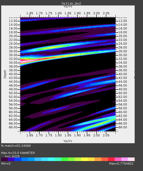
| Estimated Moho Depth: |
33.0 km |
| Estimated Crust Vp/Vs: |
1.63 |
| Assumed Crust Vp: |
6.307 km/s |
| Estimated Crust Vs: |
3.863 km/s |
| Estimated Crust Poisson's Ratio: |
0.20 |
|
| Radial Match: |
83.24888 % |
| Radial Bump: |
400 |
| Transverse Match: |
70.55159 % |
| Transverse Bump: |
400 |
| SOD ConfigId: |
19053131 |
| Insert Time: |
2019-08-16 12:07:48.696 +0000 |
| GWidth: |
2.5 |
| Max Bumps: |
400 |
| Tol: |
0.001 |
|
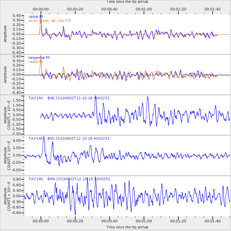
Signal To Noise
| Channel | StoN | STA | LTA |
| TA:F14K: :BHZ:20190802T12:16:18.400025Z | 10.299972 | 2.1794042E-6 | 2.1159323E-7 |
| TA:F14K: :BHN:20190802T12:16:18.400025Z | 0.94823503 | 1.6755622E-7 | 1.7670327E-7 |
| TA:F14K: :BHE:20190802T12:16:18.400025Z | 4.656547 | 7.9369045E-7 | 1.7044614E-7 |
| Arrivals |
| Ps | 3.4 SECOND |
| PpPs | 13 SECOND |
| PsPs/PpSs | 17 SECOND |


