You are here: Home > Network List > TA - USArray Transportable Network (new EarthScope stations) Stations List
> Station H16K Elim, AK, USA > Earthquake Result Viewer
H16K Elim, AK, USA - Earthquake Result Viewer
| Earthquake location: |
Southwest Of Sumatra, Indonesia |
| Earthquake latitude/longitude: |
-7.3/104.8 |
| Earthquake time(UTC): |
2019/08/02 (214) 12:03:26 GMT |
| Earthquake Depth: |
43 km |
| Earthquake Magnitude: |
6.8 Mww |
| Earthquake Catalog/Contributor: |
NEIC PDE/us |
|
| Network: |
TA USArray Transportable Network (new EarthScope stations) |
| Station: |
H16K Elim, AK, USA |
| Lat/Lon: |
64.64 N/162.24 W |
| Elevation: |
216 m |
|
| Distance: |
97.8 deg |
| Az: |
25.73 deg |
| Baz: |
269.53 deg |
| Ray Param: |
0.040076837 |
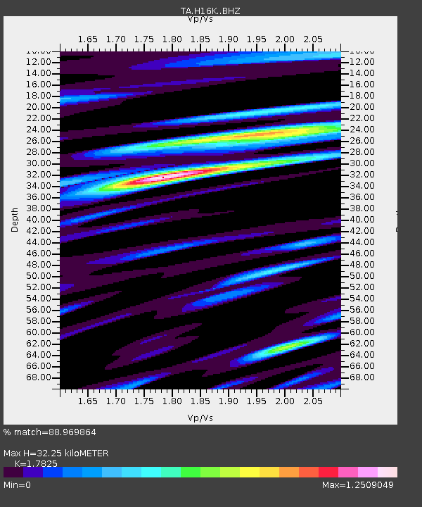
| Estimated Moho Depth: |
32.25 km |
| Estimated Crust Vp/Vs: |
1.78 |
| Assumed Crust Vp: |
6.276 km/s |
| Estimated Crust Vs: |
3.521 km/s |
| Estimated Crust Poisson's Ratio: |
0.27 |
|
| Radial Match: |
88.969864 % |
| Radial Bump: |
400 |
| Transverse Match: |
72.88535 % |
| Transverse Bump: |
400 |
| SOD ConfigId: |
19053131 |
| Insert Time: |
2019-08-16 12:07:50.612 +0000 |
| GWidth: |
2.5 |
| Max Bumps: |
400 |
| Tol: |
0.001 |
|

Signal To Noise
| Channel | StoN | STA | LTA |
| TA:H16K: :BHZ:20190802T12:16:26.025025Z | 15.766949 | 1.6970506E-6 | 1.07633426E-7 |
| TA:H16K: :BHN:20190802T12:16:26.025025Z | 2.1078358 | 2.4815245E-7 | 1.1772854E-7 |
| TA:H16K: :BHE:20190802T12:16:26.025025Z | 4.6593075 | 5.1452855E-7 | 1.10430264E-7 |
| Arrivals |
| Ps | 4.1 SECOND |
| PpPs | 14 SECOND |
| PsPs/PpSs | 18 SECOND |


