You are here: Home > Network List > TA - USArray Transportable Network (new EarthScope stations) Stations List
> Station R08A Mina, NV, USA > Earthquake Result Viewer
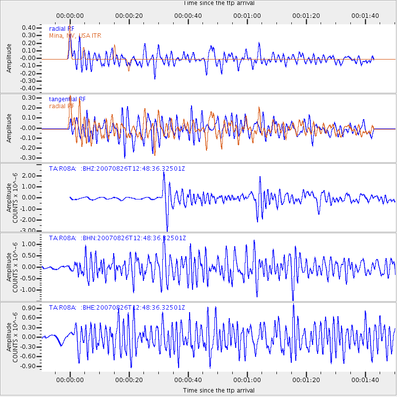
R08A Mina, NV, USA - Earthquake Result Viewer

| Earthquake location: |
Tonga Islands |
| Earthquake latitude/longitude: |
-17.5/-174.3 |
| Earthquake time(UTC): |
2007/08/26 (238) 12:37:31 GMT |
| Earthquake Depth: |
127 km |
| Earthquake Magnitude: |
5.9 MB, 6.1 MW |
| Earthquake Catalog/Contributor: |
WHDF/NEIC |
|
| Network: |
TA USArray Transportable Network (new EarthScope stations) |
| Station: |
R08A Mina, NV, USA |
| Lat/Lon: |
38.35 N/118.11 W |
| Elevation: |
1420 m |
|
| Distance: |
76.5 deg |
| Az: |
42.228 deg |
| Baz: |
234.677 deg |
| Ray Param: |
0.050626904 |
| Estimated Moho Depth: |
21.75 km |
| Estimated Crust Vp/Vs: |
1.93 |
| Assumed Crust Vp: |
6.279 km/s |
| Estimated Crust Vs: |
3.249 km/s |
| Estimated Crust Poisson's Ratio: |
0.32 |
|
| Radial Match: |
87.22778 % |
| Radial Bump: |
400 |
| Transverse Match: |
88.10897 % |
| Transverse Bump: |
400 |
| SOD ConfigId: |
2564 |
| Insert Time: |
2010-03-07 02:42:30.975 +0000 |
| GWidth: |
2.5 |
| Max Bumps: |
400 |
| Tol: |
0.001 |
|
Signal To Noise
| Channel | StoN | STA | LTA |
| TA:R08A: :BHN:20070826T12:48:36.32501Z | 1.8782097 | 1.7379789E-7 | 9.2533796E-8 |
| TA:R08A: :BHE:20070826T12:48:36.32501Z | 3.830222 | 2.9825262E-7 | 7.7868236E-8 |
| TA:R08A: :BHZ:20070826T12:48:36.32501Z | 13.686896 | 1.172986E-6 | 8.5701394E-8 |
| Arrivals |
| Ps | 3.3 SECOND |
| PpPs | 9.9 SECOND |
| PsPs/PpSs | 13 SECOND |


