You are here: Home > Network List > US - United States National Seismic Network Stations List
> Station CBKS Cedar Bluff, Kansas, USA > Earthquake Result Viewer
CBKS Cedar Bluff, Kansas, USA - Earthquake Result Viewer
| Earthquake location: |
Southern Chile |
| Earthquake latitude/longitude: |
-43.3/-74.5 |
| Earthquake time(UTC): |
2016/12/25 (360) 14:22:28 GMT |
| Earthquake Depth: |
15 km |
| Earthquake Magnitude: |
7.7 Mi |
| Earthquake Catalog/Contributor: |
NEIC PDE/at |
|
| Network: |
US United States National Seismic Network |
| Station: |
CBKS Cedar Bluff, Kansas, USA |
| Lat/Lon: |
38.81 N/99.74 W |
| Elevation: |
677 m |
|
| Distance: |
84.9 deg |
| Az: |
340.462 deg |
| Baz: |
161.788 deg |
| Ray Param: |
0.045160055 |
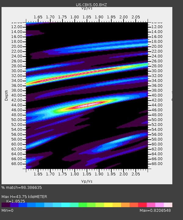
| Estimated Moho Depth: |
43.75 km |
| Estimated Crust Vp/Vs: |
1.85 |
| Assumed Crust Vp: |
6.483 km/s |
| Estimated Crust Vs: |
3.499 km/s |
| Estimated Crust Poisson's Ratio: |
0.29 |
|
| Radial Match: |
98.386635 % |
| Radial Bump: |
235 |
| Transverse Match: |
93.693184 % |
| Transverse Bump: |
400 |
| SOD ConfigId: |
1894071 |
| Insert Time: |
2017-01-08 14:31:51.974 +0000 |
| GWidth: |
2.5 |
| Max Bumps: |
400 |
| Tol: |
0.001 |
|

Signal To Noise
| Channel | StoN | STA | LTA |
| US:CBKS:00:BHZ:20161225T14:34:30.549011Z | 63.04053 | 1.2171415E-5 | 1.9307284E-7 |
| US:CBKS:00:BH1:20161225T14:34:30.549011Z | 16.332561 | 5.26914E-6 | 3.2261565E-7 |
| US:CBKS:00:BH2:20161225T14:34:30.549011Z | 4.941997 | 1.4498282E-6 | 2.933689E-7 |
| Arrivals |
| Ps | 5.9 SECOND |
| PpPs | 19 SECOND |
| PsPs/PpSs | 25 SECOND |


