You are here: Home > Network List > TA - USArray Transportable Network (new EarthScope stations) Stations List
> Station R08A Mina, NV, USA > Earthquake Result Viewer
R08A Mina, NV, USA - Earthquake Result Viewer
| Earthquake location: |
South Of Fiji Islands |
| Earthquake latitude/longitude: |
-26.2/-177.7 |
| Earthquake time(UTC): |
2007/07/17 (198) 09:39:27 GMT |
| Earthquake Depth: |
10 km |
| Earthquake Magnitude: |
5.7 MB, 6.0 MS, 6.1 MW, 6.0 MW |
| Earthquake Catalog/Contributor: |
WHDF/NEIC |
|
| Network: |
TA USArray Transportable Network (new EarthScope stations) |
| Station: |
R08A Mina, NV, USA |
| Lat/Lon: |
38.35 N/118.11 W |
| Elevation: |
1420 m |
|
| Distance: |
85.1 deg |
| Az: |
42.917 deg |
| Baz: |
231.08 deg |
| Ray Param: |
0.045017395 |
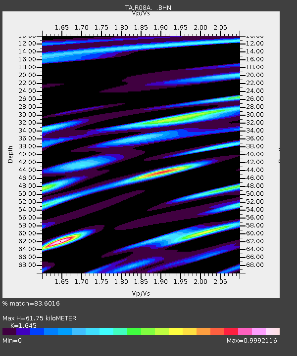
| Estimated Moho Depth: |
61.75 km |
| Estimated Crust Vp/Vs: |
1.64 |
| Assumed Crust Vp: |
6.279 km/s |
| Estimated Crust Vs: |
3.817 km/s |
| Estimated Crust Poisson's Ratio: |
0.21 |
|
| Radial Match: |
83.6016 % |
| Radial Bump: |
400 |
| Transverse Match: |
69.38871 % |
| Transverse Bump: |
400 |
| SOD ConfigId: |
2564 |
| Insert Time: |
2010-03-07 02:42:42.473 +0000 |
| GWidth: |
2.5 |
| Max Bumps: |
400 |
| Tol: |
0.001 |
|
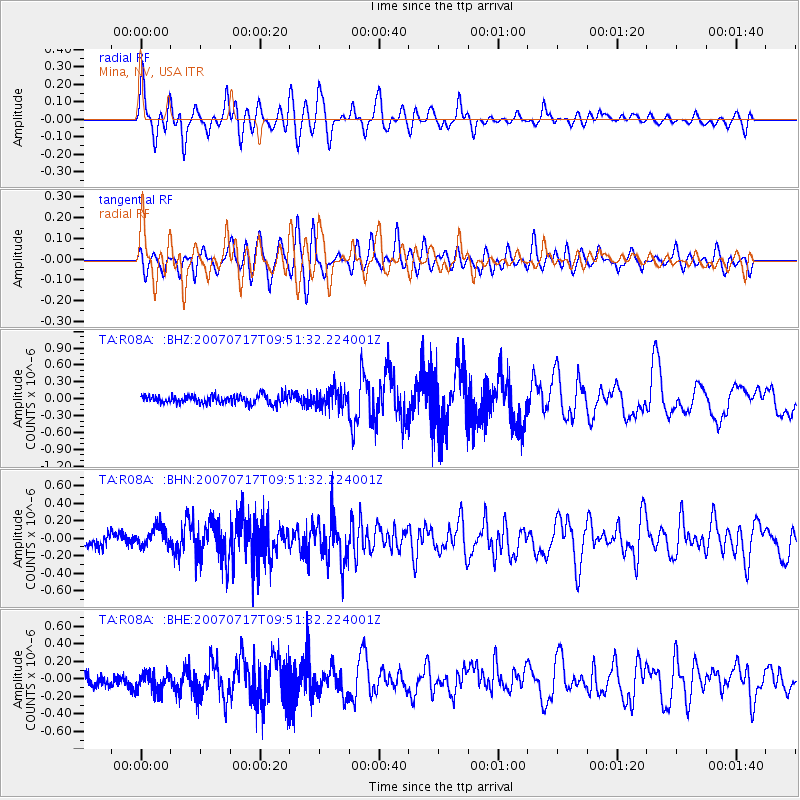
Signal To Noise
| Channel | StoN | STA | LTA |
| TA:R08A: :BHN:20070717T09:51:32.224001Z | 1.5479883 | 1.1504035E-7 | 7.4316034E-8 |
| TA:R08A: :BHE:20070717T09:51:32.224001Z | 1.6214181 | 1.0798108E-7 | 6.659669E-8 |
| TA:R08A: :BHZ:20070717T09:51:32.224001Z | 2.1345441 | 1.6110378E-7 | 7.547455E-8 |
| Arrivals |
| Ps | 6.5 SECOND |
| PpPs | 25 SECOND |
| PsPs/PpSs | 32 SECOND |


