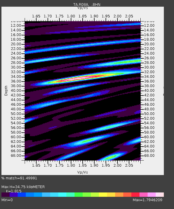
R08A Mina, NV, USA - Earthquake Result Viewer
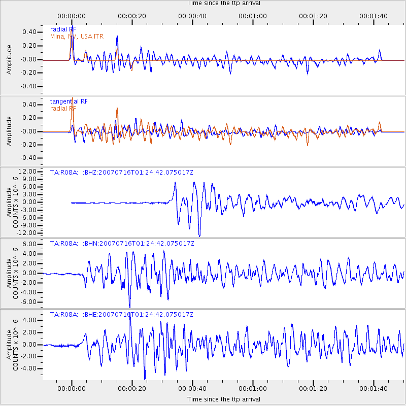
Earthquake location: Near West Coast Of Honshu, Japan
Earthquake latitude/longitude: 37.5/138.4
Earthquake time(UTC): 2007/07/16 (197) 01:13:22 GMT
Earthquake Depth: 12 km
Earthquake Magnitude: 6.5 MB, 6.4 MS, 6.6 MW, 6.5 MW
Earthquake Catalog/Contributor: WHDF/NEIC
Network: TA USArray Transportable Network (new EarthScope stations)
Station: R08A Mina, NV, USA
Lat/Lon: 38.35 N/118.11 W
Elevation: 1420 m
Distance: 76.7 deg
Az: 51.784 deg
Baz: 307.405 deg
Ray Param: 0.050792553
Estimated Moho Depth: 34.75 km
Estimated Crust Vp/Vs: 1.82
Assumed Crust Vp: 6.279 km/s
Estimated Crust Vs: 3.459 km/s
Estimated Crust Poisson's Ratio: 0.28
Radial Match: 91.49991 %
Radial Bump: 400
Transverse Match: 90.771515 %
Transverse Bump: 400
SOD ConfigId: 2564
Insert Time: 2010-03-07 02:42:48.082 +0000
GWidth: 2.5
Max Bumps: 400
Tol: 0.001

Signal To Noise

ChannelStoNSTALTA
TA:R08A: :BHN:20070716T01:24:42.075017Z12.2662257.5341086E-76.1421574E-8
TA:R08A: :BHE:20070716T01:24:42.075017Z10.8887157.178943E-76.593012E-8
TA:R08A: :BHZ:20070716T01:24:42.075017Z35.305532.6124883E-67.399657E-8
Arrivals
Ps4.6 SECOND
PpPs15 SECOND
PsPs/PpSs20 SECOND