You are here: Home > Network List > TA - USArray Transportable Network (new EarthScope stations) Stations List
> Station R08A Mina, NV, USA > Earthquake Result Viewer
R08A Mina, NV, USA - Earthquake Result Viewer
| Earthquake location: |
Kermadec Islands Region |
| Earthquake latitude/longitude: |
-31.8/-179.3 |
| Earthquake time(UTC): |
2006/05/16 (136) 10:39:23 GMT |
| Earthquake Depth: |
152 km |
| Earthquake Magnitude: |
6.8 MB, 7.4 MW, 7.4 MW |
| Earthquake Catalog/Contributor: |
WHDF/NEIC |
|
| Network: |
TA USArray Transportable Network (new EarthScope stations) |
| Station: |
R08A Mina, NV, USA |
| Lat/Lon: |
38.35 N/118.11 W |
| Elevation: |
1420 m |
|
| Distance: |
90.1 deg |
| Az: |
43.556 deg |
| Baz: |
228.277 deg |
| Ray Param: |
0.041667473 |
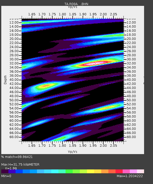
| Estimated Moho Depth: |
31.75 km |
| Estimated Crust Vp/Vs: |
1.96 |
| Assumed Crust Vp: |
6.279 km/s |
| Estimated Crust Vs: |
3.203 km/s |
| Estimated Crust Poisson's Ratio: |
0.32 |
|
| Radial Match: |
89.96421 % |
| Radial Bump: |
400 |
| Transverse Match: |
84.36736 % |
| Transverse Bump: |
400 |
| SOD ConfigId: |
2669 |
| Insert Time: |
2010-03-07 02:43:27.249 +0000 |
| GWidth: |
2.5 |
| Max Bumps: |
400 |
| Tol: |
0.001 |
|

Signal To Noise
| Channel | StoN | STA | LTA |
| TA:R08A: :BHN:20060516T10:51:34.72501Z | 1.5056101 | 1.6091096E-7 | 1.0687426E-7 |
| TA:R08A: :BHE:20060516T10:51:34.72501Z | 1.9116775 | 2.3628694E-7 | 1.2360188E-7 |
| TA:R08A: :BHZ:20060516T10:51:34.72501Z | 3.1569724 | 5.5872323E-7 | 1.7698072E-7 |
| Arrivals |
| Ps | 4.9 SECOND |
| PpPs | 15 SECOND |
| PsPs/PpSs | 20 SECOND |


