You are here: Home > Network List > TA - USArray Transportable Network (new EarthScope stations) Stations List
> Station R08A Mina, NV, USA > Earthquake Result Viewer
R08A Mina, NV, USA - Earthquake Result Viewer
| Earthquake location: |
Eastern Siberia, Russia |
| Earthquake latitude/longitude: |
60.5/167.5 |
| Earthquake time(UTC): |
2006/04/29 (119) 16:58:06 GMT |
| Earthquake Depth: |
11 km |
| Earthquake Magnitude: |
6.4 MB, 6.6 MS, 6.6 MW, 6.4 MW |
| Earthquake Catalog/Contributor: |
WHDF/NEIC |
|
| Network: |
TA USArray Transportable Network (new EarthScope stations) |
| Station: |
R08A Mina, NV, USA |
| Lat/Lon: |
38.35 N/118.11 W |
| Elevation: |
1420 m |
|
| Distance: |
50.1 deg |
| Az: |
80.853 deg |
| Baz: |
321.564 deg |
| Ray Param: |
0.06828785 |
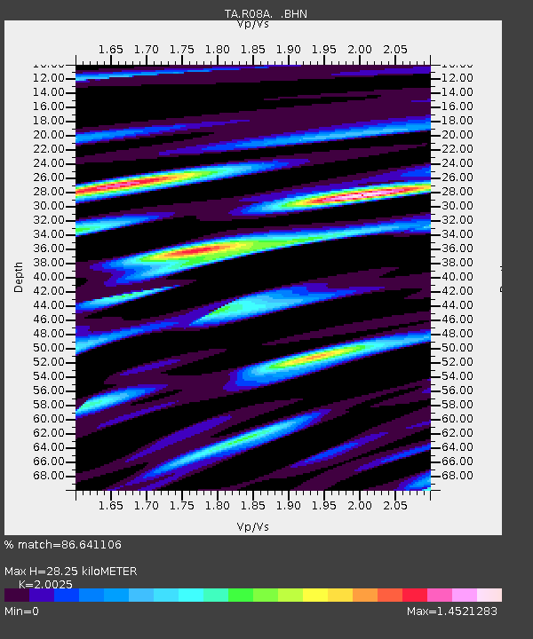
| Estimated Moho Depth: |
28.25 km |
| Estimated Crust Vp/Vs: |
2.00 |
| Assumed Crust Vp: |
6.279 km/s |
| Estimated Crust Vs: |
3.135 km/s |
| Estimated Crust Poisson's Ratio: |
0.33 |
|
| Radial Match: |
86.641106 % |
| Radial Bump: |
400 |
| Transverse Match: |
78.32091 % |
| Transverse Bump: |
400 |
| SOD ConfigId: |
2669 |
| Insert Time: |
2010-03-07 02:43:32.828 +0000 |
| GWidth: |
2.5 |
| Max Bumps: |
400 |
| Tol: |
0.001 |
|

Signal To Noise
| Channel | StoN | STA | LTA |
| TA:R08A: :BHN:20060429T17:06:30.175011Z | 1.3193249 | 2.709964E-7 | 2.0540536E-7 |
| TA:R08A: :BHE:20060429T17:06:30.175011Z | 1.4046904 | 1.9327389E-7 | 1.3759181E-7 |
| TA:R08A: :BHZ:20060429T17:06:30.175011Z | 7.389717 | 7.8903514E-7 | 1.0677474E-7 |
| Arrivals |
| Ps | 4.7 SECOND |
| PpPs | 13 SECOND |
| PsPs/PpSs | 18 SECOND |


