You are here: Home > Network List > TA - USArray Transportable Network (new EarthScope stations) Stations List
> Station R08A Mina, NV, USA > Earthquake Result Viewer
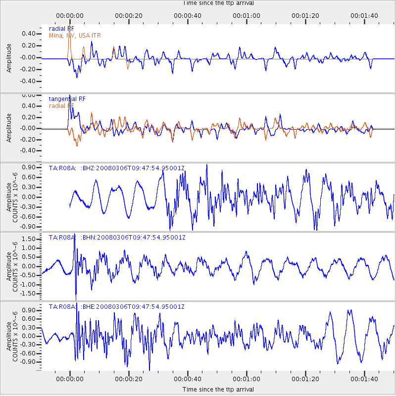
R08A Mina, NV, USA - Earthquake Result Viewer
*The percent match for this event was below the threshold and hence no stack was calculated.
| Earthquake location: |
Kamchatka Peninsula, Russia |
| Earthquake latitude/longitude: |
51.5/156.5 |
| Earthquake time(UTC): |
2008/03/06 (066) 09:38:43 GMT |
| Earthquake Depth: |
134 km |
| Earthquake Magnitude: |
5.6 MB, 5.5 MW, 5.5 MW |
| Earthquake Catalog/Contributor: |
WHDF/NEIC |
|
| Network: |
TA USArray Transportable Network (new EarthScope stations) |
| Station: |
R08A Mina, NV, USA |
| Lat/Lon: |
38.35 N/118.11 W |
| Elevation: |
1420 m |
|
| Distance: |
58.5 deg |
| Az: |
66.778 deg |
| Baz: |
313.094 deg |
| Ray Param: |
$rayparam |
*The percent match for this event was below the threshold and hence was not used in the summary stack. |
|
| Radial Match: |
54.661877 % |
| Radial Bump: |
400 |
| Transverse Match: |
78.627625 % |
| Transverse Bump: |
400 |
| SOD ConfigId: |
2504 |
| Insert Time: |
2010-03-07 02:43:52.219 +0000 |
| GWidth: |
2.5 |
| Max Bumps: |
400 |
| Tol: |
0.001 |
|
Signal To Noise
| Channel | StoN | STA | LTA |
| TA:R08A: :BHN:20080306T09:47:54.95001Z | 2.8644814 | 6.61402E-7 | 2.3089763E-7 |
| TA:R08A: :BHE:20080306T09:47:54.95001Z | 1.2897073 | 4.10528E-7 | 3.18311E-7 |
| TA:R08A: :BHZ:20080306T09:47:54.95001Z | 1.7202338 | 5.159273E-7 | 2.9991696E-7 |
| Arrivals |
| Ps | |
| PpPs | |
| PsPs/PpSs | |


