You are here: Home > Network List > US - United States National Seismic Network Stations List
> Station MIAR Mount Ida, Arkansas, USA > Earthquake Result Viewer
MIAR Mount Ida, Arkansas, USA - Earthquake Result Viewer

| Earthquake location: |
Southern Chile |
| Earthquake latitude/longitude: |
-43.3/-74.5 |
| Earthquake time(UTC): |
2016/12/25 (360) 14:22:28 GMT |
| Earthquake Depth: |
15 km |
| Earthquake Magnitude: |
7.7 Mi |
| Earthquake Catalog/Contributor: |
NEIC PDE/at |
|
| Network: |
US United States National Seismic Network |
| Station: |
MIAR Mount Ida, Arkansas, USA |
| Lat/Lon: |
34.55 N/93.58 W |
| Elevation: |
207 m |
|
| Distance: |
79.4 deg |
| Az: |
344.07 deg |
| Baz: |
165.951 deg |
| Ray Param: |
0.0489713 |
| Estimated Moho Depth: |
46.25 km |
| Estimated Crust Vp/Vs: |
1.91 |
| Assumed Crust Vp: |
6.498 km/s |
| Estimated Crust Vs: |
3.397 km/s |
| Estimated Crust Poisson's Ratio: |
0.31 |
|
| Radial Match: |
98.90525 % |
| Radial Bump: |
252 |
| Transverse Match: |
94.002426 % |
| Transverse Bump: |
400 |
| SOD ConfigId: |
1894071 |
| Insert Time: |
2017-01-08 14:32:41.453 +0000 |
| GWidth: |
2.5 |
| Max Bumps: |
400 |
| Tol: |
0.001 |
|
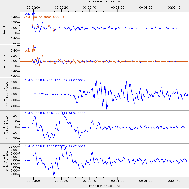
Signal To Noise
| Channel | StoN | STA | LTA |
| US:MIAR:00:BHZ:20161225T14:34:02.000Z | 61.887215 | 1.1274191E-5 | 1.8217318E-7 |
| US:MIAR:00:BH1:20161225T14:34:02.000Z | 32.009857 | 4.3679984E-6 | 1.3645791E-7 |
| US:MIAR:00:BH2:20161225T14:34:02.000Z | 9.922445 | 1.6863075E-6 | 1.6994879E-7 |
| Arrivals |
| Ps | 6.7 SECOND |
| PpPs | 20 SECOND |
| PsPs/PpSs | 27 SECOND |


