You are here: Home > Network List > C0 - Colorado Geological Survey Seismic Network Stations List
> Station T25A Trinidad, CO > Earthquake Result Viewer
T25A Trinidad, CO - Earthquake Result Viewer
| Earthquake location: |
Near East Coast Of Honshu, Japan |
| Earthquake latitude/longitude: |
37.7/141.5 |
| Earthquake time(UTC): |
2019/08/04 (216) 10:23:03 GMT |
| Earthquake Depth: |
39 km |
| Earthquake Magnitude: |
6.3 Mww |
| Earthquake Catalog/Contributor: |
NEIC PDE/us |
|
| Network: |
C0 Colorado Geological Survey Seismic Network |
| Station: |
T25A Trinidad, CO |
| Lat/Lon: |
37.08 N/104.25 W |
| Elevation: |
1800 m |
|
| Distance: |
83.9 deg |
| Az: |
47.176 deg |
| Baz: |
313.352 deg |
| Ray Param: |
0.04578372 |
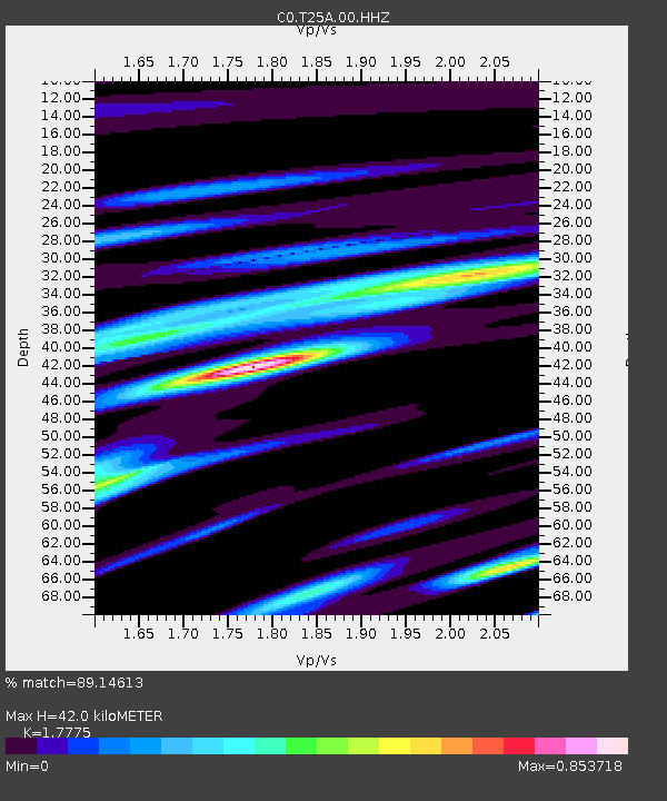
| Estimated Moho Depth: |
42.0 km |
| Estimated Crust Vp/Vs: |
1.78 |
| Assumed Crust Vp: |
6.316 km/s |
| Estimated Crust Vs: |
3.553 km/s |
| Estimated Crust Poisson's Ratio: |
0.27 |
|
| Radial Match: |
89.14613 % |
| Radial Bump: |
341 |
| Transverse Match: |
90.28879 % |
| Transverse Bump: |
377 |
| SOD ConfigId: |
19053131 |
| Insert Time: |
2019-08-18 10:26:18.851 +0000 |
| GWidth: |
2.5 |
| Max Bumps: |
400 |
| Tol: |
0.001 |
|

Signal To Noise
| Channel | StoN | STA | LTA |
| C0:T25A:00:HHZ:20190804T10:34:57.989014Z | 9.597072 | 6.2798597E-7 | 6.543517E-8 |
| C0:T25A:00:HHN:20190804T10:34:57.989014Z | 3.7116952 | 1.6335407E-7 | 4.4010637E-8 |
| C0:T25A:00:HHE:20190804T10:34:57.989014Z | 1.6783173 | 8.475892E-8 | 5.050232E-8 |
| Arrivals |
| Ps | 5.3 SECOND |
| PpPs | 18 SECOND |
| PsPs/PpSs | 23 SECOND |


