You are here: Home > Network List > CC - Cascade Chain Volcano Monitoring Stations List
> Station PR02 Puyallup River 02 > Earthquake Result Viewer
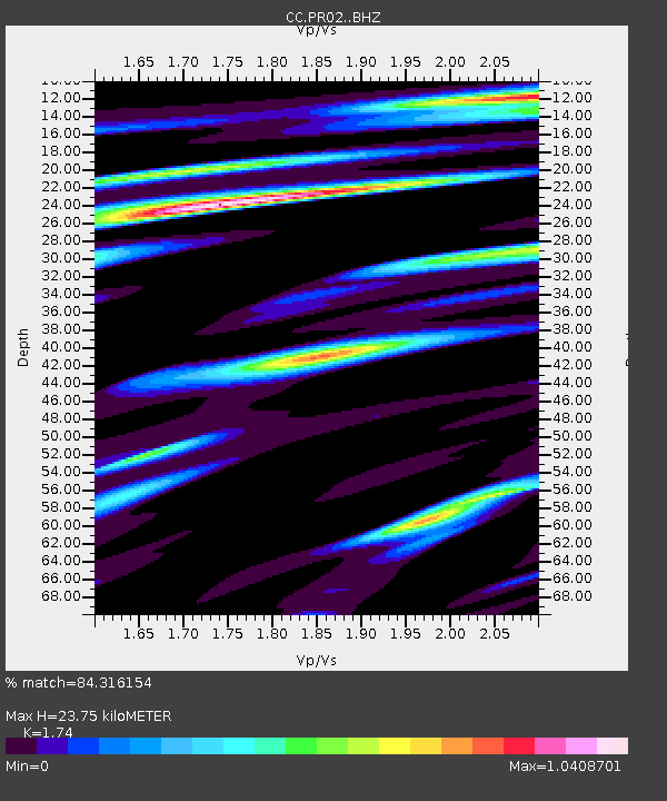
PR02 Puyallup River 02 - Earthquake Result Viewer
| Earthquake location: |
Near East Coast Of Honshu, Japan |
| Earthquake latitude/longitude: |
37.7/141.5 |
| Earthquake time(UTC): |
2019/08/04 (216) 10:23:03 GMT |
| Earthquake Depth: |
39 km |
| Earthquake Magnitude: |
6.3 Mww |
| Earthquake Catalog/Contributor: |
NEIC PDE/us |
|
| Network: |
CC Cascade Chain Volcano Monitoring |
| Station: |
PR02 Puyallup River 02 |
| Lat/Lon: |
46.92 N/122.05 W |
| Elevation: |
461 m |
|
| Distance: |
67.5 deg |
| Az: |
47.512 deg |
| Baz: |
301.471 deg |
| Ray Param: |
0.05686178 |
| Estimated Moho Depth: |
23.75 km |
| Estimated Crust Vp/Vs: |
1.74 |
| Assumed Crust Vp: |
6.566 km/s |
| Estimated Crust Vs: |
3.774 km/s |
| Estimated Crust Poisson's Ratio: |
0.25 |
|
| Radial Match: |
84.316154 % |
| Radial Bump: |
400 |
| Transverse Match: |
81.04644 % |
| Transverse Bump: |
400 |
| SOD ConfigId: |
19053131 |
| Insert Time: |
2019-08-18 10:26:36.041 +0000 |
| GWidth: |
2.5 |
| Max Bumps: |
400 |
| Tol: |
0.001 |
|

Signal To Noise
| Channel | StoN | STA | LTA |
| CC:PR02: :BHZ:20190804T10:33:25.000Z | 2.0212324 | 2.417492E-7 | 1.1960486E-7 |
| CC:PR02: :BHN:20190804T10:33:25.000Z | 0.8711341 | 1.3741119E-7 | 1.5773828E-7 |
| CC:PR02: :BHE:20190804T10:33:25.000Z | 1.8755027 | 2.4175318E-7 | 1.2890048E-7 |
| Arrivals |
| Ps | 2.8 SECOND |
| PpPs | 9.5 SECOND |
| PsPs/PpSs | 12 SECOND |


