You are here: Home > Network List > CC - Cascade Chain Volcano Monitoring Stations List
> Station PR05 Puyallup River 05 > Earthquake Result Viewer
PR05 Puyallup River 05 - Earthquake Result Viewer
| Earthquake location: |
Near East Coast Of Honshu, Japan |
| Earthquake latitude/longitude: |
37.7/141.5 |
| Earthquake time(UTC): |
2019/08/04 (216) 10:23:03 GMT |
| Earthquake Depth: |
39 km |
| Earthquake Magnitude: |
6.3 Mww |
| Earthquake Catalog/Contributor: |
NEIC PDE/us |
|
| Network: |
CC Cascade Chain Volcano Monitoring |
| Station: |
PR05 Puyallup River 05 |
| Lat/Lon: |
46.84 N/121.95 W |
| Elevation: |
1553 m |
|
| Distance: |
67.6 deg |
| Az: |
47.544 deg |
| Baz: |
301.555 deg |
| Ray Param: |
0.056797728 |
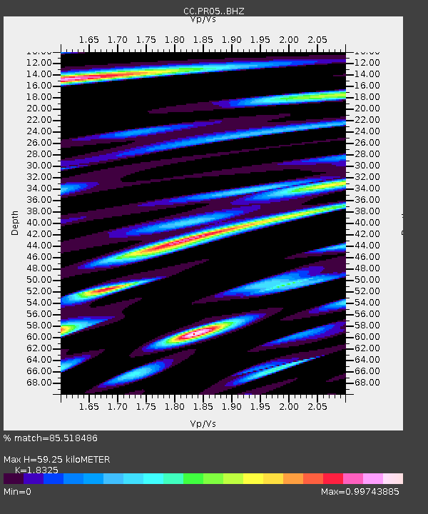
| Estimated Moho Depth: |
59.25 km |
| Estimated Crust Vp/Vs: |
1.83 |
| Assumed Crust Vp: |
6.597 km/s |
| Estimated Crust Vs: |
3.6 km/s |
| Estimated Crust Poisson's Ratio: |
0.29 |
|
| Radial Match: |
85.518486 % |
| Radial Bump: |
400 |
| Transverse Match: |
89.0268 % |
| Transverse Bump: |
400 |
| SOD ConfigId: |
19053131 |
| Insert Time: |
2019-08-18 10:26:36.861 +0000 |
| GWidth: |
2.5 |
| Max Bumps: |
400 |
| Tol: |
0.001 |
|

Signal To Noise
| Channel | StoN | STA | LTA |
| CC:PR05: :BHZ:20190804T10:33:25.619996Z | 3.0915945 | 2.3912827E-7 | 7.734787E-8 |
| CC:PR05: :BHN:20190804T10:33:25.619996Z | 0.9444019 | 7.7153246E-8 | 8.1695354E-8 |
| CC:PR05: :BHE:20190804T10:33:25.619996Z | 1.568305 | 1.3692365E-7 | 8.7306766E-8 |
| Arrivals |
| Ps | 7.8 SECOND |
| PpPs | 24 SECOND |
| PsPs/PpSs | 32 SECOND |


