You are here: Home > Network List > US - United States National Seismic Network Stations List
> Station RLMT Red Lodge, Montana, USA > Earthquake Result Viewer
RLMT Red Lodge, Montana, USA - Earthquake Result Viewer

| Earthquake location: |
Southern Chile |
| Earthquake latitude/longitude: |
-43.3/-74.5 |
| Earthquake time(UTC): |
2016/12/25 (360) 14:22:28 GMT |
| Earthquake Depth: |
15 km |
| Earthquake Magnitude: |
7.7 Mi |
| Earthquake Catalog/Contributor: |
NEIC PDE/at |
|
| Network: |
US United States National Seismic Network |
| Station: |
RLMT Red Lodge, Montana, USA |
| Lat/Lon: |
45.12 N/109.27 W |
| Elevation: |
2086 m |
|
| Distance: |
93.3 deg |
| Az: |
336.146 deg |
| Baz: |
155.353 deg |
| Ray Param: |
0.04128051 |
| Estimated Moho Depth: |
36.5 km |
| Estimated Crust Vp/Vs: |
2.10 |
| Assumed Crust Vp: |
6.242 km/s |
| Estimated Crust Vs: |
2.976 km/s |
| Estimated Crust Poisson's Ratio: |
0.35 |
|
| Radial Match: |
91.451385 % |
| Radial Bump: |
400 |
| Transverse Match: |
83.58389 % |
| Transverse Bump: |
400 |
| SOD ConfigId: |
1894071 |
| Insert Time: |
2017-01-08 14:32:53.978 +0000 |
| GWidth: |
2.5 |
| Max Bumps: |
400 |
| Tol: |
0.001 |
|
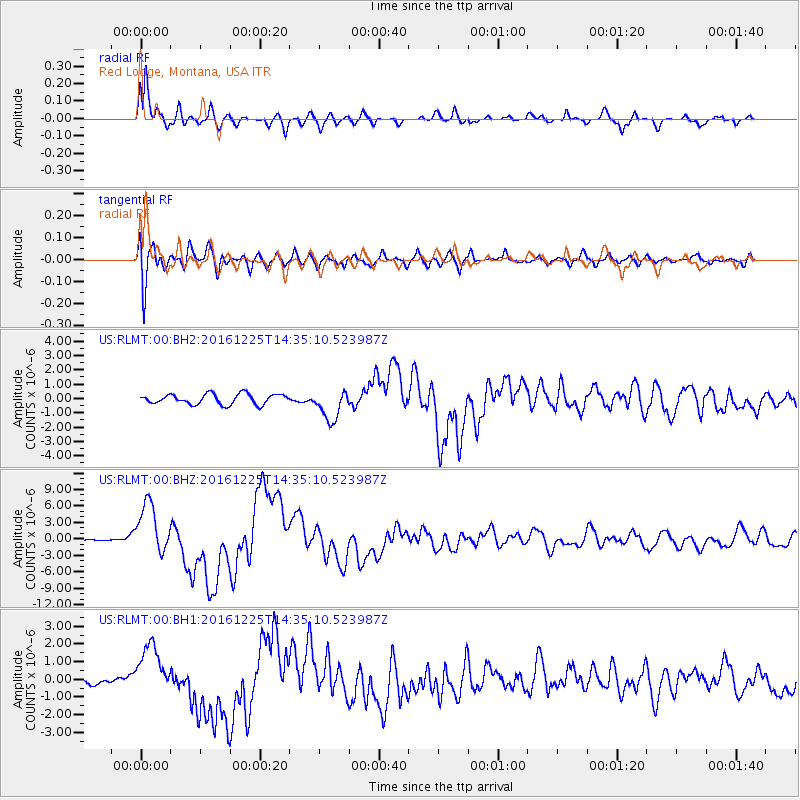
Signal To Noise
| Channel | StoN | STA | LTA |
| US:RLMT:00:BHZ:20161225T14:35:10.523987Z | 23.695805 | 4.694814E-6 | 1.9812849E-7 |
| US:RLMT:00:BH1:20161225T14:35:10.523987Z | 5.6113825 | 1.4674641E-6 | 2.615156E-7 |
| US:RLMT:00:BH2:20161225T14:35:10.523987Z | 3.042171 | 1.0774511E-6 | 3.541718E-7 |
| Arrivals |
| Ps | 6.5 SECOND |
| PpPs | 18 SECOND |
| PsPs/PpSs | 24 SECOND |


