You are here: Home > Network List > CI - Caltech Regional Seismic Network Stations List
> Station SWS Sam W. Stewart, Westmorland, CA, USA > Earthquake Result Viewer
SWS Sam W. Stewart, Westmorland, CA, USA - Earthquake Result Viewer
| Earthquake location: |
Near East Coast Of Honshu, Japan |
| Earthquake latitude/longitude: |
37.7/141.5 |
| Earthquake time(UTC): |
2019/08/04 (216) 10:23:03 GMT |
| Earthquake Depth: |
39 km |
| Earthquake Magnitude: |
6.3 Mww |
| Earthquake Catalog/Contributor: |
NEIC PDE/us |
|
| Network: |
CI Caltech Regional Seismic Network |
| Station: |
SWS Sam W. Stewart, Westmorland, CA, USA |
| Lat/Lon: |
32.94 N/115.80 W |
| Elevation: |
140 m |
|
| Distance: |
79.4 deg |
| Az: |
56.576 deg |
| Baz: |
308.102 deg |
| Ray Param: |
0.048914336 |
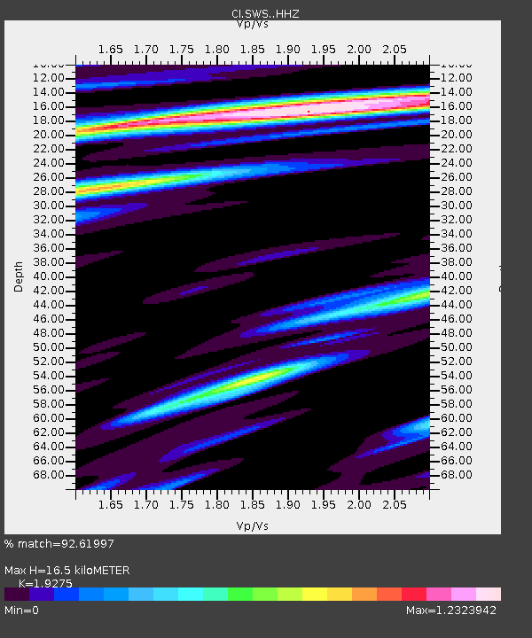
| Estimated Moho Depth: |
16.5 km |
| Estimated Crust Vp/Vs: |
1.93 |
| Assumed Crust Vp: |
6.155 km/s |
| Estimated Crust Vs: |
3.193 km/s |
| Estimated Crust Poisson's Ratio: |
0.32 |
|
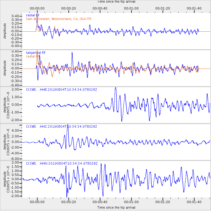
| Radial Match: |
92.61997 % |
| Radial Bump: |
400 |
| Transverse Match: |
89.900894 % |
| Transverse Bump: |
400 |
| SOD ConfigId: |
19053131 |
| Insert Time: |
2019-08-18 10:27:19.462 +0000 |
| GWidth: |
2.5 |
| Max Bumps: |
400 |
| Tol: |
0.001 |
|
Signal To Noise
| Channel | StoN | STA | LTA |
| CI:SWS: :HHZ:20190804T10:34:34.978028Z | 6.013632 | 4.682758E-7 | 7.786905E-8 |
| CI:SWS: :HHN:20190804T10:34:34.978028Z | 2.0517952 | 1.5897116E-7 | 7.747906E-8 |
| CI:SWS: :HHE:20190804T10:34:34.978028Z | 2.3114836 | 2.0822489E-7 | 9.0082786E-8 |
| Arrivals |
| Ps | 2.5 SECOND |
| PpPs | 7.7 SECOND |
| PsPs/PpSs | 10 SECOND |


