You are here: Home > Network List > GS - US Geological Survey Networks Stations List
> Station DEC04 Decatur Surface Seismic Site, Decatur, IL, USA > Earthquake Result Viewer
DEC04 Decatur Surface Seismic Site, Decatur, IL, USA - Earthquake Result Viewer
| Earthquake location: |
Near East Coast Of Honshu, Japan |
| Earthquake latitude/longitude: |
37.7/141.5 |
| Earthquake time(UTC): |
2019/08/04 (216) 10:23:03 GMT |
| Earthquake Depth: |
39 km |
| Earthquake Magnitude: |
6.3 Mww |
| Earthquake Catalog/Contributor: |
NEIC PDE/us |
|
| Network: |
GS US Geological Survey Networks |
| Station: |
DEC04 Decatur Surface Seismic Site, Decatur, IL, USA |
| Lat/Lon: |
39.88 N/88.86 W |
| Elevation: |
225 m |
|
| Distance: |
90.0 deg |
| Az: |
36.362 deg |
| Baz: |
322.349 deg |
| Ray Param: |
0.041700535 |
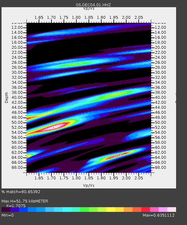
| Estimated Moho Depth: |
51.75 km |
| Estimated Crust Vp/Vs: |
1.71 |
| Assumed Crust Vp: |
6.444 km/s |
| Estimated Crust Vs: |
3.774 km/s |
| Estimated Crust Poisson's Ratio: |
0.24 |
|
| Radial Match: |
90.65392 % |
| Radial Bump: |
393 |
| Transverse Match: |
61.359142 % |
| Transverse Bump: |
400 |
| SOD ConfigId: |
19053131 |
| Insert Time: |
2019-08-18 10:29:09.575 +0000 |
| GWidth: |
2.5 |
| Max Bumps: |
400 |
| Tol: |
0.001 |
|

Signal To Noise
| Channel | StoN | STA | LTA |
| GS:DEC04:01:HHZ:20190804T10:35:28.005005Z | 4.4633193 | 1.0289755E-6 | 2.305404E-7 |
| GS:DEC04:01:HHN:20190804T10:35:28.005005Z | 1.080637 | 5.358108E-7 | 4.9582866E-7 |
| GS:DEC04:01:HHE:20190804T10:35:28.005005Z | 0.93380064 | 3.7646095E-7 | 4.0314913E-7 |
| Arrivals |
| Ps | 5.8 SECOND |
| PpPs | 21 SECOND |
| PsPs/PpSs | 27 SECOND |


