You are here: Home > Network List > UU - University of Utah Regional Network Stations List
> Station MTPU Mt. Pierson, UT, USA > Earthquake Result Viewer
MTPU Mt. Pierson, UT, USA - Earthquake Result Viewer
| Earthquake location: |
Southern Chile |
| Earthquake latitude/longitude: |
-43.3/-74.5 |
| Earthquake time(UTC): |
2016/12/25 (360) 14:22:28 GMT |
| Earthquake Depth: |
15 km |
| Earthquake Magnitude: |
7.7 Mi |
| Earthquake Catalog/Contributor: |
NEIC PDE/at |
|
| Network: |
UU University of Utah Regional Network |
| Station: |
MTPU Mt. Pierson, UT, USA |
| Lat/Lon: |
38.04 N/112.18 W |
| Elevation: |
3112 m |
|
| Distance: |
87.9 deg |
| Az: |
331.119 deg |
| Baz: |
153.474 deg |
| Ray Param: |
0.042985626 |
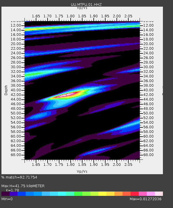
| Estimated Moho Depth: |
41.75 km |
| Estimated Crust Vp/Vs: |
1.78 |
| Assumed Crust Vp: |
6.276 km/s |
| Estimated Crust Vs: |
3.526 km/s |
| Estimated Crust Poisson's Ratio: |
0.27 |
|
| Radial Match: |
92.71754 % |
| Radial Bump: |
400 |
| Transverse Match: |
81.53032 % |
| Transverse Bump: |
400 |
| SOD ConfigId: |
1894071 |
| Insert Time: |
2017-01-08 14:33:28.899 +0000 |
| GWidth: |
2.5 |
| Max Bumps: |
400 |
| Tol: |
0.001 |
|

Signal To Noise
| Channel | StoN | STA | LTA |
| UU:MTPU:01:HHZ:20161225T14:34:45.278015Z | 45.591114 | 2.1475354E-7 | 4.7104254E-9 |
| UU:MTPU:01:HHN:20161225T14:34:45.278015Z | 6.5345516 | 7.223261E-8 | 1.1053951E-8 |
| UU:MTPU:01:HHE:20161225T14:34:45.278015Z | 3.6610723 | 3.9316454E-8 | 1.0739054E-8 |
| Arrivals |
| Ps | 5.3 SECOND |
| PpPs | 18 SECOND |
| PsPs/PpSs | 23 SECOND |


