You are here: Home > Network List > UU - University of Utah Regional Network Stations List
> Station PKCU Pink Cliffs, UT, USA > Earthquake Result Viewer
PKCU Pink Cliffs, UT, USA - Earthquake Result Viewer
| Earthquake location: |
Southern Chile |
| Earthquake latitude/longitude: |
-43.3/-74.5 |
| Earthquake time(UTC): |
2016/12/25 (360) 14:22:28 GMT |
| Earthquake Depth: |
15 km |
| Earthquake Magnitude: |
7.7 Mi |
| Earthquake Catalog/Contributor: |
NEIC PDE/at |
|
| Network: |
UU University of Utah Regional Network |
| Station: |
PKCU Pink Cliffs, UT, USA |
| Lat/Lon: |
37.44 N/112.31 W |
| Elevation: |
2834 m |
|
| Distance: |
87.4 deg |
| Az: |
330.762 deg |
| Baz: |
153.382 deg |
| Ray Param: |
0.043343212 |
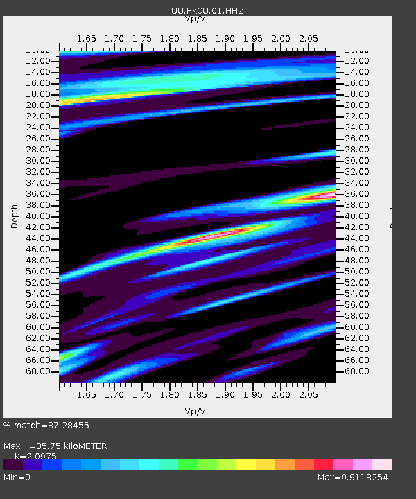
| Estimated Moho Depth: |
35.75 km |
| Estimated Crust Vp/Vs: |
2.10 |
| Assumed Crust Vp: |
6.194 km/s |
| Estimated Crust Vs: |
2.953 km/s |
| Estimated Crust Poisson's Ratio: |
0.35 |
|
| Radial Match: |
87.28455 % |
| Radial Bump: |
383 |
| Transverse Match: |
57.54027 % |
| Transverse Bump: |
308 |
| SOD ConfigId: |
1894071 |
| Insert Time: |
2017-01-08 14:33:31.928 +0000 |
| GWidth: |
2.5 |
| Max Bumps: |
400 |
| Tol: |
0.001 |
|

Signal To Noise
| Channel | StoN | STA | LTA |
| UU:PKCU:01:HHZ:20161225T14:34:42.940002Z | 19.576376 | 2.59574E-7 | 1.32595535E-8 |
| UU:PKCU:01:HHN:20161225T14:34:42.940002Z | 5.0053425 | 8.0107164E-8 | 1.6004332E-8 |
| UU:PKCU:01:HHE:20161225T14:34:42.940002Z | 2.7263374 | 5.1406797E-8 | 1.8855625E-8 |
| Arrivals |
| Ps | 6.4 SECOND |
| PpPs | 18 SECOND |
| PsPs/PpSs | 24 SECOND |


