You are here: Home > Network List > TA - USArray Transportable Network (new EarthScope stations) Stations List
> Station L08A Fields, OR, USA > Earthquake Result Viewer
L08A Fields, OR, USA - Earthquake Result Viewer
| Earthquake location: |
Taiwan Region |
| Earthquake latitude/longitude: |
24.3/122.2 |
| Earthquake time(UTC): |
2007/09/06 (249) 17:51:26 GMT |
| Earthquake Depth: |
53 km |
| Earthquake Magnitude: |
6.1 MB, 6.2 MW, 6.1 ME |
| Earthquake Catalog/Contributor: |
WHDF/NEIC |
|
| Network: |
TA USArray Transportable Network (new EarthScope stations) |
| Station: |
L08A Fields, OR, USA |
| Lat/Lon: |
42.19 N/118.34 W |
| Elevation: |
1490 m |
|
| Distance: |
93.4 deg |
| Az: |
40.417 deg |
| Baz: |
307.272 deg |
| Ray Param: |
0.041249458 |
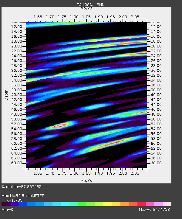
| Estimated Moho Depth: |
52.5 km |
| Estimated Crust Vp/Vs: |
1.74 |
| Assumed Crust Vp: |
6.279 km/s |
| Estimated Crust Vs: |
3.619 km/s |
| Estimated Crust Poisson's Ratio: |
0.25 |
|
| Radial Match: |
87.867485 % |
| Radial Bump: |
400 |
| Transverse Match: |
80.63019 % |
| Transverse Bump: |
400 |
| SOD ConfigId: |
2564 |
| Insert Time: |
2010-03-07 02:45:30.262 +0000 |
| GWidth: |
2.5 |
| Max Bumps: |
400 |
| Tol: |
0.001 |
|
Signal To Noise
| Channel | StoN | STA | LTA |
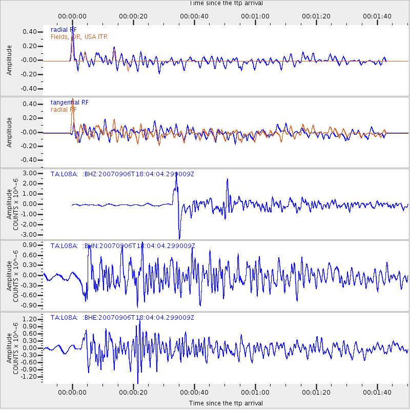
| TA:L08A: :BHN:20070906T18:04:04.299009Z | 2.598717 | 2.9694516E-7 | 1.1426607E-7 |
| TA:L08A: :BHE:20070906T18:04:04.299009Z | 4.4715066 | 2.898917E-7 | 6.483087E-8 |
| TA:L08A: :BHZ:20070906T18:04:04.299009Z | 18.760914 | 1.0146888E-6 | 5.408525E-8 |
| Arrivals |
| Ps | 6.3 SECOND |
| PpPs | 22 SECOND |
| PsPs/PpSs | 29 SECOND |


