You are here: Home > Network List > N4 - Central and EAstern US Network Stations List
> Station L46A Eue Claire, MI, USA > Earthquake Result Viewer
L46A Eue Claire, MI, USA - Earthquake Result Viewer
| Earthquake location: |
Near East Coast Of Honshu, Japan |
| Earthquake latitude/longitude: |
37.7/141.5 |
| Earthquake time(UTC): |
2019/08/04 (216) 10:23:03 GMT |
| Earthquake Depth: |
39 km |
| Earthquake Magnitude: |
6.3 Mww |
| Earthquake Catalog/Contributor: |
NEIC PDE/us |
|
| Network: |
N4 Central and EAstern US Network |
| Station: |
L46A Eue Claire, MI, USA |
| Lat/Lon: |
42.01 N/86.30 W |
| Elevation: |
223 m |
|
| Distance: |
89.4 deg |
| Az: |
33.53 deg |
| Baz: |
324.009 deg |
| Ray Param: |
0.041793995 |
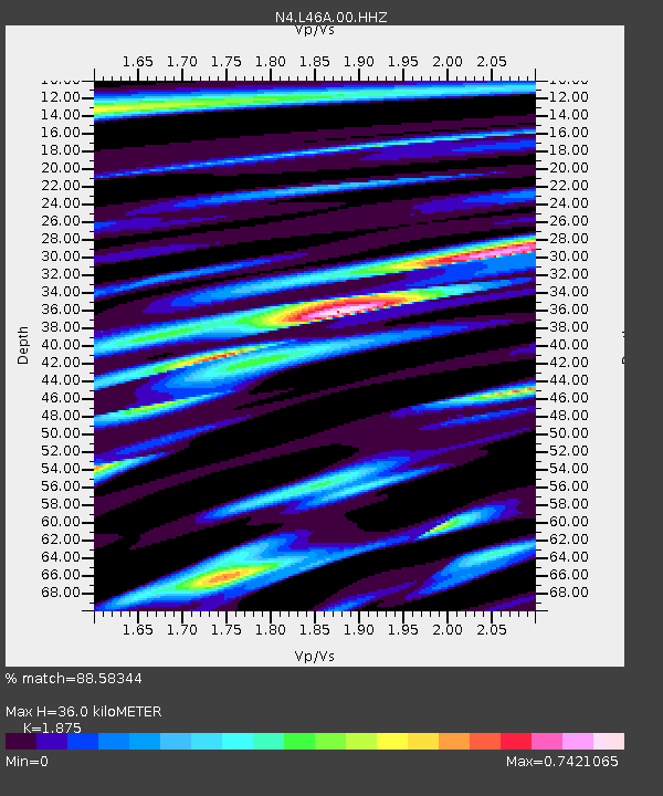
| Estimated Moho Depth: |
36.0 km |
| Estimated Crust Vp/Vs: |
1.88 |
| Assumed Crust Vp: |
6.483 km/s |
| Estimated Crust Vs: |
3.457 km/s |
| Estimated Crust Poisson's Ratio: |
0.30 |
|
| Radial Match: |
88.58344 % |
| Radial Bump: |
400 |
| Transverse Match: |
62.822235 % |
| Transverse Bump: |
400 |
| SOD ConfigId: |
19053131 |
| Insert Time: |
2019-08-18 10:30:48.459 +0000 |
| GWidth: |
2.5 |
| Max Bumps: |
400 |
| Tol: |
0.001 |
|

Signal To Noise
| Channel | StoN | STA | LTA |
| N4:L46A:00:HHZ:20190804T10:35:25.489991Z | 7.2041044 | 9.1834903E-7 | 1.274758E-7 |
| N4:L46A:00:HH1:20190804T10:35:25.489991Z | 3.29463 | 2.905723E-7 | 8.819573E-8 |
| N4:L46A:00:HH2:20190804T10:35:25.489991Z | 2.3587692 | 2.6054406E-7 | 1.1045763E-7 |
| Arrivals |
| Ps | 5.0 SECOND |
| PpPs | 16 SECOND |
| PsPs/PpSs | 21 SECOND |


