You are here: Home > Network List > UU - University of Utah Regional Network Stations List
> Station VRUT Veyo Road, Veyo, UT, USA > Earthquake Result Viewer
VRUT Veyo Road, Veyo, UT, USA - Earthquake Result Viewer
| Earthquake location: |
Southern Chile |
| Earthquake latitude/longitude: |
-43.3/-74.5 |
| Earthquake time(UTC): |
2016/12/25 (360) 14:22:28 GMT |
| Earthquake Depth: |
15 km |
| Earthquake Magnitude: |
7.7 Mi |
| Earthquake Catalog/Contributor: |
NEIC PDE/at |
|
| Network: |
UU University of Utah Regional Network |
| Station: |
VRUT Veyo Road, Veyo, UT, USA |
| Lat/Lon: |
37.46 N/113.86 W |
| Elevation: |
1874 m |
|
| Distance: |
88.0 deg |
| Az: |
329.674 deg |
| Baz: |
152.402 deg |
| Ray Param: |
0.04292033 |
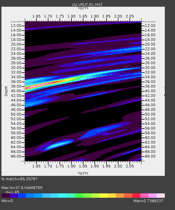
| Estimated Moho Depth: |
37.5 km |
| Estimated Crust Vp/Vs: |
1.65 |
| Assumed Crust Vp: |
6.194 km/s |
| Estimated Crust Vs: |
3.754 km/s |
| Estimated Crust Poisson's Ratio: |
0.21 |
|
| Radial Match: |
95.25797 % |
| Radial Bump: |
274 |
| Transverse Match: |
85.93184 % |
| Transverse Bump: |
366 |
| SOD ConfigId: |
1894071 |
| Insert Time: |
2017-01-08 14:33:47.673 +0000 |
| GWidth: |
2.5 |
| Max Bumps: |
400 |
| Tol: |
0.001 |
|

Signal To Noise
| Channel | StoN | STA | LTA |
| UU:VRUT:01:HHZ:20161225T14:34:45.700012Z | 28.702732 | 2.1109891E-7 | 7.354662E-9 |
| UU:VRUT:01:HHN:20161225T14:34:45.700012Z | 9.865511 | 6.2687924E-8 | 6.35425E-9 |
| UU:VRUT:01:HHE:20161225T14:34:45.700012Z | 2.3747048 | 2.4736705E-8 | 1.0416749E-8 |
| Arrivals |
| Ps | 4.0 SECOND |
| PpPs | 16 SECOND |
| PsPs/PpSs | 20 SECOND |


