You are here: Home > Network List > N4 - Central and EAstern US Network Stations List
> Station U38B Mount Pleasant Farm, Gravette, AR, USA > Earthquake Result Viewer
U38B Mount Pleasant Farm, Gravette, AR, USA - Earthquake Result Viewer
| Earthquake location: |
Near East Coast Of Honshu, Japan |
| Earthquake latitude/longitude: |
37.7/141.5 |
| Earthquake time(UTC): |
2019/08/04 (216) 10:23:03 GMT |
| Earthquake Depth: |
39 km |
| Earthquake Magnitude: |
6.3 Mww |
| Earthquake Catalog/Contributor: |
NEIC PDE/us |
|
| Network: |
N4 Central and EAstern US Network |
| Station: |
U38B Mount Pleasant Farm, Gravette, AR, USA |
| Lat/Lon: |
36.44 N/94.39 W |
| Elevation: |
389 m |
|
| Distance: |
89.9 deg |
| Az: |
41.906 deg |
| Baz: |
318.952 deg |
| Ray Param: |
0.041708343 |
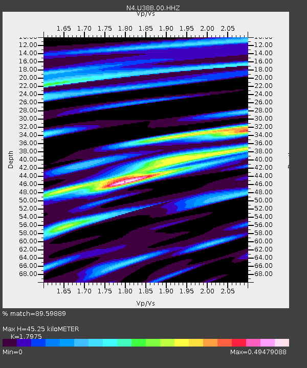
| Estimated Moho Depth: |
45.25 km |
| Estimated Crust Vp/Vs: |
1.80 |
| Assumed Crust Vp: |
6.53 km/s |
| Estimated Crust Vs: |
3.633 km/s |
| Estimated Crust Poisson's Ratio: |
0.28 |
|
| Radial Match: |
89.59889 % |
| Radial Bump: |
331 |
| Transverse Match: |
82.37696 % |
| Transverse Bump: |
400 |
| SOD ConfigId: |
19053131 |
| Insert Time: |
2019-08-18 10:31:18.235 +0000 |
| GWidth: |
2.5 |
| Max Bumps: |
400 |
| Tol: |
0.001 |
|

Signal To Noise
| Channel | StoN | STA | LTA |
| N4:U38B:00:HHZ:20190804T10:35:27.500Z | 6.3947144 | 5.8893653E-7 | 9.2097395E-8 |
| N4:U38B:00:HH1:20190804T10:35:27.500Z | 3.0600388 | 1.3646664E-7 | 4.4596376E-8 |
| N4:U38B:00:HH2:20190804T10:35:27.500Z | 1.7304828 | 1.1715609E-7 | 6.770139E-8 |
| Arrivals |
| Ps | 5.6 SECOND |
| PpPs | 19 SECOND |
| PsPs/PpSs | 25 SECOND |


