You are here: Home > Network List > NE - New England Seismic Network Stations List
> Station EMMW Machias, ME, USA > Earthquake Result Viewer
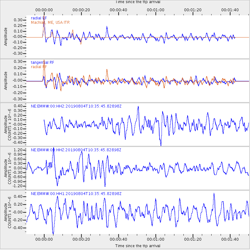
EMMW Machias, ME, USA - Earthquake Result Viewer
*The percent match for this event was below the threshold and hence no stack was calculated.
| Earthquake location: |
Near East Coast Of Honshu, Japan |
| Earthquake latitude/longitude: |
37.7/141.5 |
| Earthquake time(UTC): |
2019/08/04 (216) 10:23:03 GMT |
| Earthquake Depth: |
39 km |
| Earthquake Magnitude: |
6.3 Mww |
| Earthquake Catalog/Contributor: |
NEIC PDE/us |
|
| Network: |
NE New England Seismic Network |
| Station: |
EMMW Machias, ME, USA |
| Lat/Lon: |
44.71 N/67.46 W |
| Elevation: |
35 m |
|
| Distance: |
93.9 deg |
| Az: |
20.268 deg |
| Baz: |
337.346 deg |
| Ray Param: |
$rayparam |
*The percent match for this event was below the threshold and hence was not used in the summary stack. |
|
| Radial Match: |
72.52133 % |
| Radial Bump: |
400 |
| Transverse Match: |
68.26114 % |
| Transverse Bump: |
400 |
| SOD ConfigId: |
19053131 |
| Insert Time: |
2019-08-18 10:31:28.992 +0000 |
| GWidth: |
2.5 |
| Max Bumps: |
400 |
| Tol: |
0.001 |
|
Signal To Noise
| Channel | StoN | STA | LTA |
| NE:EMMW:00:HHZ:20190804T10:35:45.82898Z | 1.8276438 | 3.552603E-7 | 1.943816E-7 |
| NE:EMMW:00:HH1:20190804T10:35:45.82898Z | 1.4741806 | 1.9208977E-7 | 1.3030274E-7 |
| NE:EMMW:00:HH2:20190804T10:35:45.82898Z | 1.1294472 | 8.147878E-8 | 7.21404E-8 |
| Arrivals |
| Ps | |
| PpPs | |
| PsPs/PpSs | |


