You are here: Home > Network List > NM - Cooperative New Madrid Seismic Network Stations List
> Station CLTN Cedars of Lebanon,TN > Earthquake Result Viewer
CLTN Cedars of Lebanon,TN - Earthquake Result Viewer
| Earthquake location: |
Near East Coast Of Honshu, Japan |
| Earthquake latitude/longitude: |
37.7/141.5 |
| Earthquake time(UTC): |
2019/08/04 (216) 10:23:03 GMT |
| Earthquake Depth: |
39 km |
| Earthquake Magnitude: |
6.3 Mww |
| Earthquake Catalog/Contributor: |
NEIC PDE/us |
|
| Network: |
NM Cooperative New Madrid Seismic Network |
| Station: |
CLTN Cedars of Lebanon,TN |
| Lat/Lon: |
36.09 N/86.33 W |
| Elevation: |
208 m |
|
| Distance: |
94.2 deg |
| Az: |
37.034 deg |
| Baz: |
323.874 deg |
| Ray Param: |
0.041080736 |
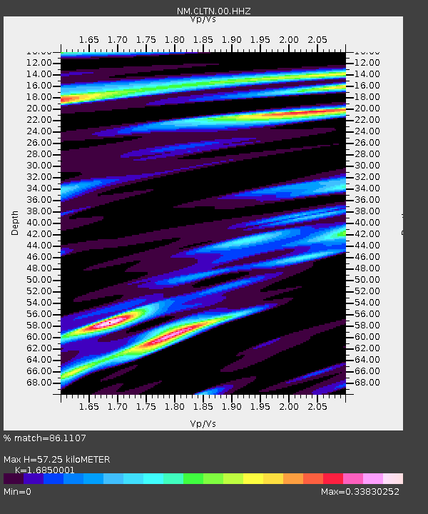
| Estimated Moho Depth: |
57.25 km |
| Estimated Crust Vp/Vs: |
1.69 |
| Assumed Crust Vp: |
6.444 km/s |
| Estimated Crust Vs: |
3.824 km/s |
| Estimated Crust Poisson's Ratio: |
0.23 |
|
| Radial Match: |
86.1107 % |
| Radial Bump: |
377 |
| Transverse Match: |
75.20169 % |
| Transverse Bump: |
400 |
| SOD ConfigId: |
19053131 |
| Insert Time: |
2019-08-18 10:31:32.610 +0000 |
| GWidth: |
2.5 |
| Max Bumps: |
400 |
| Tol: |
0.001 |
|

Signal To Noise
| Channel | StoN | STA | LTA |
| NM:CLTN:00:HHZ:20190804T10:35:47.445008Z | 6.9238725 | 1.69095E-7 | 2.4422027E-8 |
| NM:CLTN:00:HHN:20190804T10:35:47.445008Z | 2.8092759 | 5.8873E-8 | 2.0956646E-8 |
| NM:CLTN:00:HHE:20190804T10:35:47.445008Z | 1.5096427 | 3.4938324E-8 | 2.3143437E-8 |
| Arrivals |
| Ps | 6.2 SECOND |
| PpPs | 23 SECOND |
| PsPs/PpSs | 30 SECOND |


