You are here: Home > Network List > NM - Cooperative New Madrid Seismic Network Stations List
> Station MGMO Mountain Grove, MO > Earthquake Result Viewer
MGMO Mountain Grove, MO - Earthquake Result Viewer
| Earthquake location: |
Near East Coast Of Honshu, Japan |
| Earthquake latitude/longitude: |
37.7/141.5 |
| Earthquake time(UTC): |
2019/08/04 (216) 10:23:03 GMT |
| Earthquake Depth: |
39 km |
| Earthquake Magnitude: |
6.3 Mww |
| Earthquake Catalog/Contributor: |
NEIC PDE/us |
|
| Network: |
NM Cooperative New Madrid Seismic Network |
| Station: |
MGMO Mountain Grove, MO |
| Lat/Lon: |
37.15 N/92.27 W |
| Elevation: |
453 m |
|
| Distance: |
90.4 deg |
| Az: |
40.15 deg |
| Baz: |
320.22 deg |
| Ray Param: |
0.041668497 |
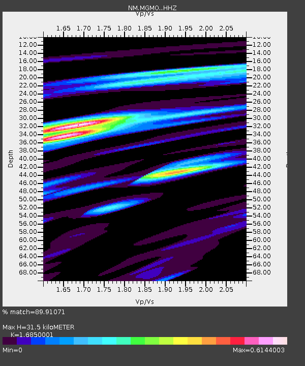
| Estimated Moho Depth: |
31.5 km |
| Estimated Crust Vp/Vs: |
1.69 |
| Assumed Crust Vp: |
6.53 km/s |
| Estimated Crust Vs: |
3.876 km/s |
| Estimated Crust Poisson's Ratio: |
0.23 |
|
| Radial Match: |
89.91071 % |
| Radial Bump: |
248 |
| Transverse Match: |
70.3682 % |
| Transverse Bump: |
290 |
| SOD ConfigId: |
19053131 |
| Insert Time: |
2019-08-18 10:31:36.270 +0000 |
| GWidth: |
2.5 |
| Max Bumps: |
400 |
| Tol: |
0.001 |
|

Signal To Noise
| Channel | StoN | STA | LTA |
| NM:MGMO: :HHZ:20190804T10:35:30.090027Z | 5.963244 | 4.8624594E-7 | 8.1540506E-8 |
| NM:MGMO: :HHN:20190804T10:35:30.090027Z | 2.2928834 | 1.6906081E-7 | 7.373284E-8 |
| NM:MGMO: :HHE:20190804T10:35:30.090027Z | 1.7219216 | 1.0102655E-7 | 5.867082E-8 |
| Arrivals |
| Ps | 3.4 SECOND |
| PpPs | 13 SECOND |
| PsPs/PpSs | 16 SECOND |


