You are here: Home > Network List > TA - USArray Transportable Network (new EarthScope stations) Stations List
> Station L08A Fields, OR, USA > Earthquake Result Viewer
L08A Fields, OR, USA - Earthquake Result Viewer
| Earthquake location: |
Gulf Of Mexico |
| Earthquake latitude/longitude: |
26.3/-86.6 |
| Earthquake time(UTC): |
2006/09/10 (253) 14:56:08 GMT |
| Earthquake Depth: |
14 km |
| Earthquake Magnitude: |
5.9 MB, 5.5 MS, 5.8 MW, 5.8 MW |
| Earthquake Catalog/Contributor: |
WHDF/NEIC |
|
| Network: |
TA USArray Transportable Network (new EarthScope stations) |
| Station: |
L08A Fields, OR, USA |
| Lat/Lon: |
42.19 N/118.34 W |
| Elevation: |
1490 m |
|
| Distance: |
30.4 deg |
| Az: |
309.462 deg |
| Baz: |
111.188 deg |
| Ray Param: |
0.07933137 |
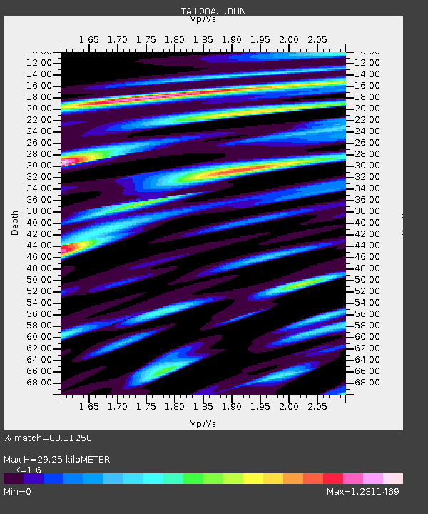
| Estimated Moho Depth: |
29.25 km |
| Estimated Crust Vp/Vs: |
1.60 |
| Assumed Crust Vp: |
6.279 km/s |
| Estimated Crust Vs: |
3.924 km/s |
| Estimated Crust Poisson's Ratio: |
0.18 |
|
| Radial Match: |
83.11258 % |
| Radial Bump: |
400 |
| Transverse Match: |
76.718475 % |
| Transverse Bump: |
400 |
| SOD ConfigId: |
2665 |
| Insert Time: |
2010-03-07 02:46:00.968 +0000 |
| GWidth: |
2.5 |
| Max Bumps: |
400 |
| Tol: |
0.001 |
|
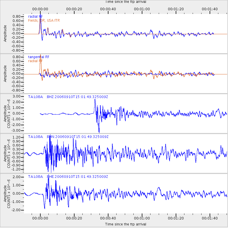
Signal To Noise
| Channel | StoN | STA | LTA |
| TA:L08A: :BHN:20060910T15:01:49.325009Z | 3.153868 | 4.2934875E-7 | 1.3613402E-7 |
| TA:L08A: :BHE:20060910T15:01:49.325009Z | 5.7180624 | 7.24952E-7 | 1.2678281E-7 |
| TA:L08A: :BHZ:20060910T15:01:49.325009Z | 15.174805 | 1.2814747E-6 | 8.444752E-8 |
| Arrivals |
| Ps | 3.0 SECOND |
| PpPs | 11 SECOND |
| PsPs/PpSs | 14 SECOND |


