You are here: Home > Network List > O2 - Oklahoma Consolidated Temporary Seismic Networks Stations List
> Station FW04 Hopeton, Oklahoma, USA > Earthquake Result Viewer
FW04 Hopeton, Oklahoma, USA - Earthquake Result Viewer
| Earthquake location: |
Near East Coast Of Honshu, Japan |
| Earthquake latitude/longitude: |
37.7/141.5 |
| Earthquake time(UTC): |
2019/08/04 (216) 10:23:03 GMT |
| Earthquake Depth: |
39 km |
| Earthquake Magnitude: |
6.3 Mww |
| Earthquake Catalog/Contributor: |
NEIC PDE/us |
|
| Network: |
O2 Oklahoma Consolidated Temporary Seismic Networks |
| Station: |
FW04 Hopeton, Oklahoma, USA |
| Lat/Lon: |
36.60 N/98.67 W |
| Elevation: |
448 m |
|
| Distance: |
87.4 deg |
| Az: |
44.351 deg |
| Baz: |
316.473 deg |
| Ray Param: |
0.043271255 |
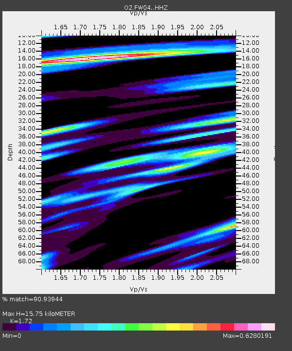
| Estimated Moho Depth: |
15.75 km |
| Estimated Crust Vp/Vs: |
1.72 |
| Assumed Crust Vp: |
6.426 km/s |
| Estimated Crust Vs: |
3.736 km/s |
| Estimated Crust Poisson's Ratio: |
0.24 |
|
| Radial Match: |
90.93944 % |
| Radial Bump: |
236 |
| Transverse Match: |
85.0584 % |
| Transverse Bump: |
321 |
| SOD ConfigId: |
19053131 |
| Insert Time: |
2019-08-18 10:32:06.726 +0000 |
| GWidth: |
2.5 |
| Max Bumps: |
400 |
| Tol: |
0.001 |
|

Signal To Noise
| Channel | StoN | STA | LTA |
| O2:FW04: :HHZ:20190804T10:35:16.039979Z | 3.1962276 | 6.919635E-7 | 2.1649383E-7 |
| O2:FW04: :HHN:20190804T10:35:16.039979Z | 1.1551985 | 2.7674236E-7 | 2.3956258E-7 |
| O2:FW04: :HHE:20190804T10:35:16.039979Z | 0.8686602 | 1.7982273E-7 | 2.0701158E-7 |
| Arrivals |
| Ps | 1.8 SECOND |
| PpPs | 6.5 SECOND |
| PsPs/PpSs | 8.3 SECOND |


