You are here: Home > Network List > TA - USArray Transportable Network (new EarthScope stations) Stations List
> Station L08A Fields, OR, USA > Earthquake Result Viewer
L08A Fields, OR, USA - Earthquake Result Viewer
| Earthquake location: |
Near Coast Of Peru |
| Earthquake latitude/longitude: |
-13.6/-76.6 |
| Earthquake time(UTC): |
2007/08/17 (229) 13:18:13 GMT |
| Earthquake Depth: |
48 km |
| Earthquake Magnitude: |
5.6 MB, 5.6 MS, 5.9 MW |
| Earthquake Catalog/Contributor: |
WHDF/NEIC |
|
| Network: |
TA USArray Transportable Network (new EarthScope stations) |
| Station: |
L08A Fields, OR, USA |
| Lat/Lon: |
42.19 N/118.34 W |
| Elevation: |
1490 m |
|
| Distance: |
67.5 deg |
| Az: |
327.617 deg |
| Baz: |
135.515 deg |
| Ray Param: |
0.056820825 |
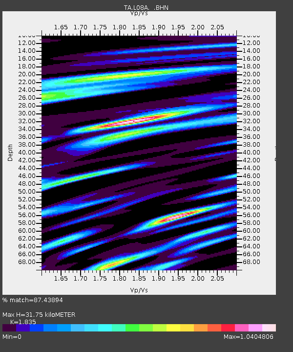
| Estimated Moho Depth: |
31.75 km |
| Estimated Crust Vp/Vs: |
1.84 |
| Assumed Crust Vp: |
6.279 km/s |
| Estimated Crust Vs: |
3.422 km/s |
| Estimated Crust Poisson's Ratio: |
0.29 |
|
| Radial Match: |
87.43894 % |
| Radial Bump: |
400 |
| Transverse Match: |
83.48813 % |
| Transverse Bump: |
400 |
| SOD ConfigId: |
2564 |
| Insert Time: |
2010-03-07 02:46:13.373 +0000 |
| GWidth: |
2.5 |
| Max Bumps: |
400 |
| Tol: |
0.001 |
|
Signal To Noise
| Channel | StoN | STA | LTA |
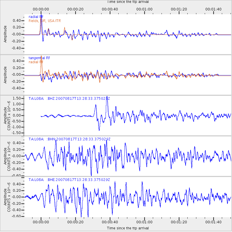
| TA:L08A: :BHN:20070817T13:28:33.375029Z | 4.520777 | 1.7903754E-7 | 3.9603265E-8 |
| TA:L08A: :BHE:20070817T13:28:33.375029Z | 6.0759206 | 1.9878001E-7 | 3.271603E-8 |
| TA:L08A: :BHZ:20070817T13:28:33.375029Z | 11.239953 | 5.6477063E-7 | 5.0246708E-8 |
| Arrivals |
| Ps | 4.4 SECOND |
| PpPs | 14 SECOND |
| PsPs/PpSs | 18 SECOND |


