You are here: Home > Network List > WI - West Indies IPGP Network Stations List
> Station MAGL Barre de l'ile, Saint louis, Marie Galante > Earthquake Result Viewer
MAGL Barre de l'ile, Saint louis, Marie Galante - Earthquake Result Viewer
| Earthquake location: |
Southern Chile |
| Earthquake latitude/longitude: |
-43.3/-74.5 |
| Earthquake time(UTC): |
2016/12/25 (360) 14:22:28 GMT |
| Earthquake Depth: |
15 km |
| Earthquake Magnitude: |
7.7 Mi |
| Earthquake Catalog/Contributor: |
NEIC PDE/at |
|
| Network: |
WI West Indies IPGP Network |
| Station: |
MAGL Barre de l'ile, Saint louis, Marie Galante |
| Lat/Lon: |
15.95 N/61.28 W |
| Elevation: |
150 m |
|
| Distance: |
60.2 deg |
| Az: |
14.685 deg |
| Baz: |
191.092 deg |
| Ray Param: |
0.06168349 |
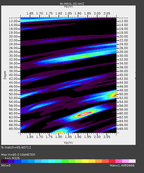
| Estimated Moho Depth: |
60.0 km |
| Estimated Crust Vp/Vs: |
1.93 |
| Assumed Crust Vp: |
5.88 km/s |
| Estimated Crust Vs: |
3.043 km/s |
| Estimated Crust Poisson's Ratio: |
0.32 |
|
| Radial Match: |
85.60712 % |
| Radial Bump: |
400 |
| Transverse Match: |
64.17488 % |
| Transverse Bump: |
400 |
| SOD ConfigId: |
1894071 |
| Insert Time: |
2017-01-08 14:34:06.017 +0000 |
| GWidth: |
2.5 |
| Max Bumps: |
400 |
| Tol: |
0.001 |
|

Signal To Noise
| Channel | StoN | STA | LTA |
| WI:MAGL:00:HHZ:20161225T14:32:04.039978Z | 3.640335 | 7.6246392E-6 | 2.0944883E-6 |
| WI:MAGL:00:HHN:20161225T14:32:04.039978Z | 2.0628285 | 6.3555804E-6 | 3.0810027E-6 |
| WI:MAGL:00:HHE:20161225T14:32:04.039978Z | 1.2706921 | 4.493771E-6 | 3.536475E-6 |
| Arrivals |
| Ps | 9.9 SECOND |
| PpPs | 29 SECOND |
| PsPs/PpSs | 39 SECOND |


